Press release 2016-06-14 at 12:19
A new tool has been developed for predicting and managing the water balance of mines, and to produce forecasts for mining operators. This tool, which is based on SYKE’s Watershed simulation and forecast system (WSFS), allows mining operators to prepare for changes in water quantities and floods, and ensure the adequacy of the water supply. In addition to this, the system provides information for regulating lakes in the mining area. The tool was designed as part of the recently concluded WaterSmart project.
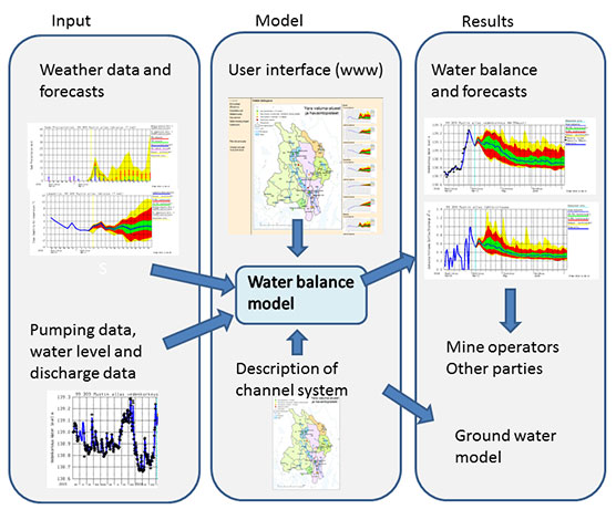
The water balance model can be used to calculate the inflows of reservoirs, flows from one reservoir to another and water levels in different reservoirs. The data obtained from continuous measurements in the mining area are automatically transferred to the model. Manual measurements from the mining operator are entered through the user interface but can be automated. The water balance model was tested in practice in the Siilinjärvi mine.

The model is developed from a WSFS system, which is used for real time simulation and forecasting of water balances and water quantities in different parts of Finland. © Photo: WaterSmart project
More detailed information to aid in planning
The water balance system can aid in planning the dimensions of dams, pumping stations and reservoirs, as well as in the review of different structural options. Furthermore, the system provides estimates of changes in a mine area's water balance, caused by climate change.
Calculation service provided by SYKE
The commercialisation of the WaterSmart project's results was planned in cooperation with the other research institutions and companies that participated in the project. The resulting water balance model and service tailored for mining areas includes:
- Hydrological data
- Weather service (FMI)
- Real-time simulation and forecast of water balance and up-keeping of the model
- Operative service (up-keeping of the simulation system and real-time data transfer, analysis of results and reports)
- A map-based user interface, which includes reservoir management, weather observations and forecasts, basin inflow, water level and drainage forecasts, simulating snow water equivalent, soil moisture and percolation and changes in groundwater storage
- Simulated groundwater input as percolation, which can be entered into hydraulicgroundwater models (such as operated by GTK)
- Automatic warnings for mine personnel (such as water level and outflow capacity alerts, as well as heavy rain and flood alerts)
The water balance model can be integrated into other models or systems
The groundwater model developed by GTK uses percolation from the water balance model at the Siilinjärvi mine as input for the ground water simulation. In addition to this, the water balance model can also be connected to the process simulation and management system of the mine.
Cooperation partners and funding of the project
The project was conducted by SYKE, GTK and VTT. In addition to TEKES, the project was funded by Outotec Oyj, EHP-Tekniikka Oy, ÅF-Consult Oy, Yara Suomi Oy and Boliden Kylylahti.
More information
Senior Research Scientist Kirsti Krogerus, Finnish Environment Institute SYKE, tel. +358 295 251 321, firstname.lastname@ymparisto.fi
Leading Hydrologist Bertel Vehviläinen, Finnish Environment Institute SYKE, tel. +358 295 251 731, firstname.lastname@ymparisto.fi
Leading Researcher Antti Pasanen, Geological Survey of Finland (GTK), tel. +358 50 349 1876 or +358 295 033 630, firstname.lastname@gtk.fi
Communication Specialist Katri Haatainen, Finnish Environment Institute SYKE, tel. +358 295 251 135, firstname.lastname@ymparisto.fi