Press release 2014-06-16 at 11:05
The Stockholm and Helsinki regions are divided into various types of core, peri-urban, and rural areas.
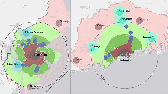
A recent study conducted by the University of Helsinki and the Finnish Environment Institute on the metropolitan areas of Helsinki and Stockholm indicates that the urban form in these regions has developed partially in different directions.
Growth in the Helsinki region has occurred mainly in the peri-urban areas and the car zones.
In Stockholm, the growth has focused in areas near the city centre.
In order to develop the Helsinki Metropolitan Area, the researchers suggest decision-making at the metropolitan level, increasing the efficiency of supplementary construction and supporting polycentricity.
Stockholm ahead of Helsinki in the development of the core city
In Stockholm, the population and jobs are concentrated more in the vicinity of the city centre than in Helsinki. In the 2000s, 40% of the population growth in Stockholm took place within eight kilometres of the city centre. In the Helsinki region, the equivalent area encompassed only 15% of growth.
“The core areas of both cities exhibit the same kind of development, in which shore areas are more and more actively utilised for housing, work and recreation, as port and industrial operations move further away,” Researcher Panu Söderström describes. “However, Stockholm is way ahead of Helsinki in the implementation of these repurposed areas.”
In the Helsinki Metropolitan Area, the most significant growth has taken place outside the eight-kilometre radius around the city centre. The population growth has been even stronger in the peri-urban areas surrounding the metropolitan area. The majority of growth in these areas has occurred in sparsely structured urban areas where people primarily travel by car. In the Stockholm region, the growth of the peri-urban areas has focused in the vicinity railway links.
Sub-centres have grown in Stockholm and partially regressed in the Helsinki Metropolitan Area
In the Helsinki Metropolitan Area, there are 11 diverse sub-centres where housing, services and jobs intermingle, whereas their number in the core areas of the Stockholm region is 10. The largest sub-centres of the urban regions, such as Pasila in Helsinki, and Sundbyberg–Solna and the ICT hub Kista in Stockholm, currently house tens of thousands of jobs that play a significant role in terms of the polycentric structure of the regions.
In the 2000s, however, Leppävaara has been the only sub-centre in the Helsinki Metropolitan Area to show substantial growth and, in contrast to Stockholm, the numbers of jobs in many sub-centres have even declined. At the same time, the populations of many sub-centres have increased.
In the suburban areas of the Helsinki Metropolitan Area, new jobs have generally been created in condensed workplace areas outside the centres, such as the Keilaniemi–Otaniemi and Karamalmi areas in Espoo, and the vicinity of Helsinki Airport and Ring Road III in Vantaa. Alongside the traditional sub-centres, the Helsinki Metropolitan Area has seen the formation of new kinds of functional concentrations to which commercial activities and jobs have gravitated. The scale and accessibility of these concentrations differ from the traditional centres, and they have primarily come together at the terms of car traffic.
Supporting polycentricity as a solution to problems with urban form
In an international comparison, the lengths of commutes in the Helsinki region correspond to those of significantly larger metropolitan areas. According to a study by the Finnish Environment Institute and Tampere University of Technology, the development of polycentricity is one solution for keeping lengthening commutes in check.
In Helsinki, polycentricity has, so far, increased in terms of housing, but the same is yet to happen with regard to jobs. “What we need is a common vision of the network of sub-centres and an efficient public transportation network to link the various centres. In addition to this, we need to redirect multiple different steering systems – financial ones, in particular – and develop and implement new financial instruments to finance future growth”, Senior Research Scientist Mika Ristimäki of the Finnish Environment Institute says, listing the prerequisites for the development of a polycentric structure.
Major policies regarding urban form must be decided at the metropolitan level
In large urban regions, issues concerning land use, traffic, housing and general economic development policies are largely regional, which is why functional cross-municipal decision-making is required to solve them. “Decision-making regarding the control of metropolitan-level urban form has been slow and ambiguous in the Helsinki region, which makes it harder to predict the development of the area. Moreover, the results of the study indicate that the efforts to stop the decentralisation of the urban form in the region have been unsuccessful,” Professor Harry Schulman of the University of Helsinki estimates.
In Stockholm County, the elected County Council is responsible for regional planning and the organisation of public transportation and health care in the county region. The development plan prepared under the council’s leadership presents a shared desired state with regard to the future of the region’s development. The network of sub-centres presented in the development plan aiming for 2030 will, in future, serve as the foundation for the urban form of the metropolitan area.
The county-level decision-making in the Stockholm region is one example of how to organise metropolitan area administration in urban regions. The experiences gained in Stockholm can also fuel considerations regarding the administrative model of the Helsinki region.
The studies are based on the zone division of urban form
The comparative study of the urban forms of Helsinki and Stockholm was implemented as a cooperative effort between the Department of Geosciences and Geography at the University of Helsinki and the Finnish Environment Institute’s built environment and land use research. The project is part of the Metropolitan Region Urban Research and Cooperation Program (KatuMetro). The research report was published in the SYKE publications series.
At the same time, the joint Urban Zone project of the Finnish Environment Institute and Tampere University of Technology prepared a separate report on the urban form of the Helsinki Metropolitan Area. It was published in the SYKE reports series.
The studies share an approach incorporating geospatial data, in which cities are examined as urban zones (pedestrian, public transport and car zones) organised based on travel options and the structural characteristic of areas. The zone division of urban form was prepared earlier in the Urban Zone project for 34 Finnish urban regions.
More information
Urban form of the Helsinki Metropolitan Area
Senior Research Scientist Mika Ristimäki, Finnish Environment Institute SYKE
tel. +358 295 251 567, forename.surname@ymparisto.fi
Head of Unit Ville Helminen, Finnish Environment Institute SYKE
tel. +358 295 251 166, firstname.lastname@ymparisto.fi
Helsinki–Stockholm comparison
Researcher Panu Söderström, Finnish Environment Institute SYKE and University of Helsinki,
tel. +358 295 251 672, firstname.lastname@ymparisto.fi
Professor Harry Schulman, University of Helsinki
tel. +358 505 596 611, firstname.lastname@helsinki.fi
Communications
Communication Specialist Matti Lindholm, Finnish Environment Institute SYKE,
tel. +358 295 251 380, firstname.lastname@ymparisto.fi