In this project an ecosystem model assembly, covering key nutrient inputs and outputs, is being developed for nutrient load management and impact assessment, and monitoring of Finnish coastal areas. The model assembly is already constructed for the Archipelago Sea (2013-2015) and in present project it is further developed and implemented to the Gulf of Finland and Bothnian Sea ecosystems. The model framework includes nutrient and freshwater load from drainage basin (WSFS-VEMALA model), 3-dimensional hydrodynamics (3D COHERENS, including nutrient transport and background load), simple biogeochemistry (FICOS model, developed in the project), and an empirical-statistical model for the estimation of internal load from sediments. These models are linked together to evaluate ecosystem responses to current external nutrient load and its management. We want to strengthen the scientific and quantitative basis of water management and decision making. The results can also be applied in the water protection related socio-economic governance and policy analysis.
Coastal system modeling is challenging
Coastal systems are of major importance in Baltic Sea estuarine and coastal waters. These areas bind and modify load of new nutrients, originating from drainage basin and point sources (fish farms etc.). Variable background nutrient inputs from the main basin of the Baltic Sea may also have a key role in eutrophication dynamics. Present Baltic Sea models lack adequate coastal descriptions and they are also too coarse for the modelling of the complex bathymetry (bottom topography) and current fields, and hence nutrient load responses of our coastal ecosystems.
The goal is to produce tools for water management
Due to the complexity of the scene, coupling 3D hydrodynamics with a variety of biogeochemical processes, our nutrient load model assembly provides an essential toolbox for the governmental authorities working with drainage basin and coastal management. These authorities include in particular the regional environmental administration (ELY Centers) on the local level and the Ministry of Environment on wider and whole Baltic Sea level. The easy-to-use, quantitative modeling tool supports and facilitates implementation of their tasks, which include fish farming impact assessments and permissions, and coastal ecosystem state and management assessments to meet EU Water Framework Directive (WFD) and HELCOM Baltic Sea Action Plan (BSAP) targets (new assessment round starts in 2018). The new model assembly enables more transparent and ecologically sound evaluation of policies and decision alternatives, and improves predictions in impact assessment. In addition the project results and the model development will benefit marine ecosystem modelers, and more generally end-users ranging from those who need the ecosystem framework professionally (e.g. research, education, decision making) to general public interested in environmental issues.
Linking several models
Nutrient load from drainage basin will be estimated, including terrestrial and inland water hydrological and biogeochemical processes and the effects of soil types and land use alternatives. As a novel feature, the model (VEMALA) estimates the loads of mineral fractions of nitrogen and phosphorus in addition to respective total loads. The internal nutrient loading, i.e. nutrient release from sediments to the water column, is estimated statistically by combining extensive, high-quality empirical measurements from Archipelago Sea with spatial and temporal distribution of sediment properties and water column conditions (e.g. season, trophic status and oxygen conditions).
Adequate coverage of the complex bottom topography and fragmented Finnish coastline are the major challenges in our 3D hydrodynamical modelling. We will construct a high-resolution (0,25 nm) coastal model nested with a lower-resolution (2 nm) whole Baltic Sea model. Biogeochemistry of coastal systems and their responses to nutrient load is evaluated by FICOS model, which is developed from existing SEABED water quality model (KTH). We utilize monitoring and remote sensing data for the validation of models and for the estimation of boundary conditions required by the coastal model.

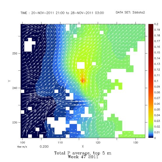
Example of model simulation: transport and dilution of nutrient emissions from a point source in N Archipelago Sea (total phosphorus, μg/l). The arrows show average direction and velocity of contemporary surface currents. Source: Current project
Further information
Risto Lignell, Head of Marine Ecosystem Functioning and Modeling Unit
Finnish Environment Institute (SYKE), Marine Research Centre
E-mail: firstname.lastname@environment.fi
Tel. 0295 251 377