Press release 2017-06-13 at 8:30

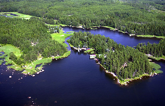
The special features of both sea and land areas should be considered in integrated coastal spatial planning. Photo by Riku Lumiaro.
The planning of coastal spatial management enables account to be taken of the effects of land-sea activities on coastal nature and local business activities. The objective of such planning is to examine all human activities affecting coastal areas and to direct the use of coastal and marine areas on a more environmentally-friendly basis. These experiences should be used by coastline countries, both nationally and more widely at EU level. In maritime spatial planning, the aim is to ensure the sustainable use of European maritime areas.
Finnish Environment Institute is taking part in SustainBaltic project led by the Department of Geography and Geology at the University of Turku. In this project, the integrated use and management of coastal areas is being developed in Southwest Finland through spatial planning. The project involves compiling GIS data on underwater nature, nature types and species values on land, as well as on different types of pressure on these, such as routes, fisheries, etc. in support of planning.
By combining GIS data, experts have identified valuable nature entities that form coherent complexes. Through the examination of ecological values and pressure from human activities, planning processes can be developed in order to minimise the harm caused to nature and human welfare, and to avert potential conflicts.
Although the spatial development of land is being implemented in regional and municipal zoning, maritime spatial planning is bringing new challenges to planning activities. Areas in coastal regions can be made more attractive by introducing an integrated land-sea perspective. Public, accessible coasts can be crucial to the development of local nature tourism.
For example, coasts for public use in the Bothnian Sea National Park are attractive for hikers and nature tourists, while also functioning as gateways for the free movement of organisms between the mainland and archipelago. Dense coastal development without long-term planning may reduce opportunities for the general public to make recreational use of the area, while municipal decision-makers may find tax benefits associated with coastal development attractive. The role of the regions is of the utmost importance in wider-scale spatial development.
Comprehensive information and involvement as the basis of sustainability
The Velmu project has involved the collection of comprehensive information on coastal underwater ecosystems. It is now possible to examine coastal underwater and above-water nature in a certain area. When planning, for example, it is possible to observe cane-grass areas, sandbanks, flada areas isolated from the sea, as well as valuable coastal meadows and grasslands.

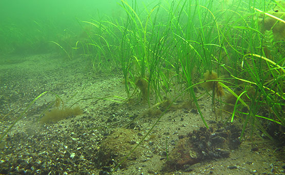
Underwater biodiversity is the basis of integrated coastal spatial planning. © Suvi Kiviluoto
Underwater nature is subject to various pressures, such as construction and harbour activities, fisheries, farming and tourism. For the sake of sustainable use, it would be important to integrate these types of pressures with natural values and the expectations of various actors.
Participants in this project include Finnish and Estonian planners, experts in nature and environmental management, as well as representatives of business life and nature protection organisations. Participatory discussion can reduce conflicts between activities. For example, biodiversity and areas that are important to tourism should be considered when planning the use of natural resources. This would contribute to the better management of various risks, such as climate change and oil catastrophes.
The project is being funded by around one million euros from the European Regional Development Fund (ERDF), under the Interreg Central Baltic Programme 2014–2020. Other participants in the project include the Regional Council of Satakunta in Finland, as well as Tallinn University (Tallinna Ülikool) and Estonian University of Life Sciences (Eesti Maaülikool) in Estonia. This project group is representative of Finnish and Estonian expertise in regional planning, GIS and participatory assessment.
Recent results from the project will be presented at the open seminar held at Tallinn University on 13 June from 1pm to 4pm.
Additional information
Petteri Vihervaara, Senior Research Scientist, Finnish Environment Institute (SYKE), tel. +358 2 952 51 740, firstname.lastname@ymparisto.fi
Docent Reija Hietala, Project Manager, University of Turku, Department of Geography and Geology, tel. +358 50 344 9812, +358 2 952 51 740, firstname.lastname@utu.fi
Kirsi Kostamo, Head of Unit, Velmu project, Finnish Environment Institute (SYKE), tel. +358 295 251 315, firstname.lastname@ymparisto.fi

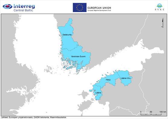
Project areas in Finland and Estonia. In Finland, integrated coastal spatial planning is being examined in Satakunta and Southwest Finland.