The key theme of the SEVIRA project is co-operation between Finland and Russia. One aspect of the project is the long-term monitoring of the state of the coastal waters of the Eastern Gulf of Finland. In 2021, the project carried out sampling and measurement campaigns in the coastal sea areas on the Finnish and Russian sides. The field campaigns took place in the Bay of Virojoki and the Vyborg Bay, which are used to assess the current state of these coastal water areas.
Coastal monitoring benefits from satellite observations
In addition to coastal sampling trips, the SEVIRA project has utilized almost daily overpassing satellites across the Eastern Gulf of Finland. The project utilizes, among other things, the European Union's flagship satellite series, the Copernicus program. The space program provides a wide range of observations suitable for environmental monitoring in various aspects.
In the SEVIRA project, the use of satellite observatios has focused on determining algal abundance, water turbidity and seawater temperature. Satellite observations can be utilized for the days and areas that have been sufficiently cloudless during the satellite overflight, i.e., typically just before noon.
Satellite observations can be utilized as daily maps that show the current state of the water area. For example, if there is an evident cyanobacteria bloom occuring in the Eastern Gulf of Finland. On the other hand, a summary of the observations collected from the summerly season can be calculated from the satellite observations. These can be used to assess the state of coastal waters and to compare with previous years. Furthermore, the great benefit of satellite observations is that observations can be made on both sides of the border at the same time, whenever it is cloudless.
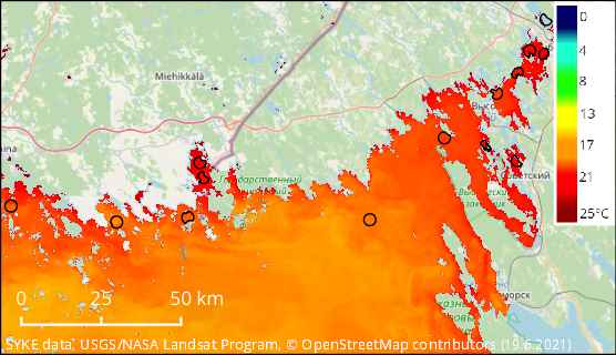
Satellite observation of summerly temperature variation in the SEVIRA project area (June 19, 2021). The summer of 2021 was warm, so the surface water was also particularly warm in the Eastern Gulf of Finland. On daily basis, the observations of surface temperature can be made with1 km resolution, but as accurately as in this example map (with an accuracy of 100 m) about every one and a half weeks.
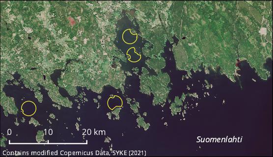
Monitoring stations of the Vyborg Bay
Field campaign measurements and satellite observations have good mutual correspondence at station sites. In the SEVIRA project, a total of nine new satellite monitoring stations were implemented in different parts of the Vyborg Bay. Additional stations were supplemented for the sea areas on the Finnish side, so that there are now 13 satellite monitoring stations in the Eastern Gulf of Finland.
Satellite observations of water quality are automatically collected from these monitoring stations even after the project. Observations for all the available years were supplemented for the stations. For chlorophyll-a, which describes the amount of algae, the data will start in 2015, but surface temperature observations are available even from 2004 onwards.
Satellite monitoring stations were added to the Bay of Vironlahti this year. Observations of these stations can continue to be used to monitor fluctuations in surface water temperature, algae and turbidity. In addition to station sampling, observations are now collected from satellite observations (in the yellow areas of the image). Rivers flowing into the area bring nutrient- and humus-rich and, at times, very turbid river waters to the coast, the spread of which is especially visible in the spring during the melting season and after the rains. The variation in water quality in Virolahti itself is quite large and the impact of the Virojoki catchment area flowing into its northern part is often clear.
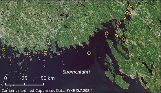
SEVIRA project satellite monitoring station sites. Observations are monitored for variations in temperature, amount of algae, and turbidity. After the project, satellite observations will still be collected in the yellow areas illustrated on the map. The shape of the observation areas varies because they are delimited by shallow areas and islands around the station.
Futher information
-
Jenni Attila, Finnish Environment Institute SYKE,
firstname.lastname@syke.fi
-
Jouni Törrönen, South-Eastern Centre for Economic Development, Transport and the Environment, firstname.lastname@ely-keskus.fi
-
TARKKA web map appliation