ICP IM site FI01
|
|
|
|
|
|
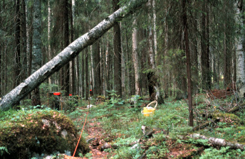
Intensive monitoring plot 3 in Valkea-Kotinen catchment, photo: Katariina Mäkelä.
|
|
General features
The Valkea-Kotinen catchment is the smallest of the Finnish sites belonging to the ICP IM Network, being only about 30 ha. It contains a small headwater lake, Valkea-Kotinen. Upland forests cover about 62% and peatlands 25% of the total area (Tuominen et al). The forests are mainly old virgin forests with several canopy layers. The area has a lot of dead standing trees and and fallen decaying logs. The dominant trees are 80-150 years old Norway spruce (Picea abies). Old birch (Betula spp.), aspen (Populus tremula) and Scots pine (Pinus sylvestris) occur among the spruce. The oldest emergent trees are Scots pine over 350 years old. Traces of forest fires can be seen on old tree trunks. Forest fires occured every 25-30 years in the late 18th and 19th centuries. The fires usually affected only a small part of the catchment. On the west side of the of the lake, some of the broadleaved trees have been felled by beavers. The southern part of the catchment has been subject to forest management, and most of the trees in that section are only 40-50 years old.
The Valkea-Kotinen catchment was protected as a part of the Kotinen State Forest Reserve in 1955. The protected area was enlarged in 1987, and at the beginning of 1994 the area was made a nature reserve.
The first IM activities were started in 1987 and include most of the ICP IM subprogrammes.
|
Country:
|
Finland
|
|
Province/Municipality:
|
Häme / Lammi
|
|
Area of site (hectares):
|
30
|
|
Location (Lat/Long):
|
61° 14' N, 25° 04' E
|
|
Elevation (above sea level):
|
Min: 150 m
Max: 190 m
|
|
Annual mean precipitation:
|
618 mm
|
|
Annual mean temperature:
|
3.1 °C
|
|
Dominant vegetation:
|
Mesic and rich heath forests, Norway spruce (Picea abies) dominant tree
|
|
Dominant soil type:
|
Histosols (peat) account 1/5 of the land area, located mainly around the lake. Most of the nonorganic soil may be classified as dystric cambisols with transition to podzols.
|
|
Biotopes (hectares):
|
Upland forests 19, peatlands 8, lake 4 (Tuominen et al)
|
Geology and soils
The bedrock at the Valkea-Kotinen catchment is part of an old peneplane. The dominant bedrock type is 1900-million-year-old mica gneiss which had originally been clay and sand sediments. These sediments were then thoroughly metamorphosed so that their original structures are no longer apparent. The strike of the bedrock is approximately south-north
and the dip is to the west, vearing 30-80°.
The direction of ice movement during the last Ice Age was 340°. The area is supraaquatic, i.e. above the highest shoreline of the former stages of the Baltic. The highest coastline of the postglacial Yoldia Sea in the area is about 139 m above sea level. The area is covered with a 1-3-m-thick silty till.
Histosols (peat) acount about one fifth of the the land area of the catchment and are located mainly around the lake. Most of the the nonorganic soil may be classified as dystric cambisols with transition to podzols, particularly on the upper slopes.
Vegetation
The dominant forest vegetation site types (Hämet-Ahti 1989, forest site types) are mesic and rich heaths. Both site types are relatively rich in nutrients. The lake is surrounded by a narrow zone of dwarf shrub pine bog, which turns into a treeles fen area to the south of the lake. Beyond the zone of dwarf shrub pine bog, a thin strip of thin-peated spruce heath forest occurs on the the east side of the lake. A somewhat more extensive area of peat resembling Vaccinium myrtillus drained peatland forest occurs on the the west side of the lake (Eurola et al. 1984, mire types).
Areas of forest site types in Valkea-Kotinen Integrated Monitoring area
|
Mesic heath forests
|
11.2 ha
|
|
Rich heath forests
|
9.4 ha
|
|
Submesic heath forests
|
0.2 ha
|
Areas of mire types in Valkea-Kotinen Integrated Monitoring area
|
Hummock level bogs/pine mires
|
2.4 ha
|
|
Drained peatland forests
|
2.3 ha
|
|
Spruce mires
|
1.8 ha
|
|
Other
|
0.2 ha
|
Maps
Including also the Musta-Kotinen catchment
FI01 Basemap
FI01 Soilmaterial
FI01 Soiltype
References
Bergström, I., K. Mäkelä and M. Starr (eds), 1995. Integrated Monitoring Programme in Finland: First National Report. Ministry of the Environment, Environment Policy Department, Helsinki. Rep. 1.
Eurola, S., Hicks, S. & Kaakinen, E. 1984: Key to Finnish mire types.In: Moore, P. (ed), European mires: 11-117. Academic Press, London.
Hämet-Ahti, L. 1989: The main features of Finnish vegetation. In: Alalammi, P. (ed), Atlas of Finland. Folio 141-143, Vegetation and Flora:1-2. National Board of Survey, Geographical Society of Finland.
Tuominen, S., Kokko A., Mäkelä K. 2001. Mappings and inventories of vegetation and tree stands at the Finnish Integrated Monitoring areas. Mimiograph series of Finnish Environment Institute 241. Finnish Environment Institute, 52 s. (In Finnish with English abstract). http://hdl.handle.net/10138/40847