ICP IM site FI05
|
|
|
|
|
|
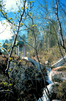
Output from the Vuoskojärvi catchment, photo: Irina Bergström.
|
|
General features
The Vuoskojärvi monitoring area comprises 178 ha, of which Lake Vuoskojärvi covers about 8%.
The Vuoskojärvi IM area has the greates range in relief of the Finnish sites belonging to the ICP IM network, being 105 m. Subalpine birch forests dominate on the mineral soils. In 1964-1965 the geometrid moth Epirrita autumnata caused damage and defoliated large areas of birch forests in the vicinity. Damaged mountain birch (Betula pubescens spp. tortuosa ) forests cover about 7 ha of the Vuoskojärvi catchment. There are also stands of Scots pine (Pinus sylvestris) in the area, which may be regarded as disjunct fragments of the coniferous zone.
The monitoring area is situated in the northern part of Kevo Strict Nature Reserve which was incorporated into the original Kevo Reserve in 1982.
The first monitoring activity, i.e. physico-chemical lake water sampling, started in 1988 and most of the other ICP IM subprogrammes soon thereafter.
Full monitoring in accordance with IM programme at Pesosjärvi (Kainuu) and Vuoskojärvi (Lapland) sites stopped in 1999, and monitoring was carried out with limited programme between 2000 and 2015.
|
Country:
|
Finland
|
|
Province/Municipality:
|
Lapland / Utsjoki
|
|
Area of site (hectares):
|
178
|
|
Location (Lat/Long):
|
69° 44' N, 26° 57' E
|
|
Elevation (above sea level):
|
Min: 135 m
Max: 240 m
|
|
Annual mean precipitation:
|
395 mm
|
|
Annual mean temperature:
|
-1.9 °C
|
|
Dominant vegetation:
|
Mountain birch forests
|
|
Dominant soil type:
|
Podzols
|
|
Biotopes (hectares): Mapped area used here 20ha smaller than the catchment
|
Upland forest 152.5, peatlands 20.5, lake 18.2, other 1.9
|
Geology and soils
The topographic and geophysical maps indicate that the Vuoskojärvi catchment is situated in a strong south-north fracture zone approximately parallel to the Teno River canyon. The Vuoskojärvi monitoring area is situated in a contact zone between granulite and granitic gneiss, which is typical of the eastern boundary of the granulite belt in the region. The main bedrock types are gneisses and amphibolites which usually contain small amounts of sulphide minerals. The strike of the bedrock is approximately south-north and the dip runs at 40-50° to the east.
During the last Ice Age, the main ice flow direction was roughly south-north. The continental ice withdrew from the area about 10000 years ago and left behind till deposits in the valleys. The hilltops generally lack a cover of loose material except for scattered block fields. The area is supraaquatic.
No inventory of the soils has yet been made, but given the area of peatland in the catchment (20.5 ha) histosols can be expected to account for about 13% of the soils. Most of the remaining soils can be expected to be podzols. Lithic leptosols are also anticipated. A discontinous hard iron pan layer in the top of the enrichted B (podzol) horizon occurs in the area of mountain birch southeast of the lake.
Vegetation
In terms of geobotanical zonation (Ahti et al. 1968) Vuoskojärvi is situated in the northern boundary of the northern boreal zone. The forest vegetation belongs to the continental subzone of the subalpine mountain birch zone (Hämet-Ahti 1989, Ahti et al. 1968).
Subalpine birch forests dominate on the mineral soils. Mountain birch accounts for almost all of the tree and shrub layers. Lichens and Pleurozium schreberi dominate in the bottom layer. Empetrum hermafroditum and, on mesic sites, also Vaccinium myrtillus dominate in the field layer. Pine forests occur especially in the southern part of the catchment. Orohemiarctic heaths dominated by dwarf shrubs and lichens are found on the upper slopes of the catchments.
The boundary between mineral soils and peatlands is not very clear. The vegetation characteristically forms a mosaic of paludified heaths and mire vegetation. The peat layer is usually thin, with a broad influence of groundwater and surface water. The nutrient status of the mire vegetation varies from oligotrophic to eutrophic. Typical mire types are Betula nana pine mires and rich pine fens. Other combination types of mire vegetation are also common.
Areas of forest site types in Vuoskojärvi Integrated Monitoring area (according to old catchment boundary, which was about 20 ha larger)
|
Mountain birch forests of Empetrum-Myrtillus - type
|
75.6 ha
|
|
Pine forests
|
44.0 ha
|
|
Mountain birch forests of subalpine Empetrum-Lichenes-Plerozium -type
|
24.4 ha
|
|
Mountain birch forests of subalpine Empetrum-Lichenes -type
|
8.6 ha
|
Maps
FI05 Basemap
References
Ahti, T., Hämet-Ahti, L. & Jalas, J. 1968: Vegetation zones and and their sections in northwestern Europe. - Ann. Bot. Fennici 5:169-211.
Bergström, I., K. Mäkelä and M. Starr (eds), 1995. Integrated Monitoring Programme in Finland: First National Report. Ministry of the Environment, Environment Policy Department, Helsinki. Rep. 1.
Hämet-Ahti, L. 1989: The main features of Finnish vegetation. In: Alalammi, P. (ed), Atlas of Finland. Folio 141-143, Vegetation and Flora:1-2. National Board of Survey, Geographical Society of Finland.