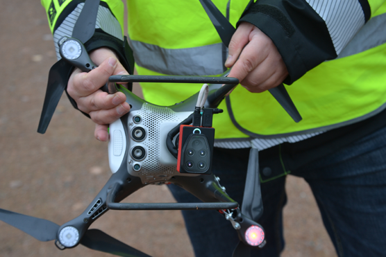
The multispectral camera allows the interpretation of water quality, such as turbidity and chlorophyll, when more accurate temporal and spatial information is needed. The project uses data fusion to combine drone data with other data sources such as satellite, ship and in-situ. Virojoki on October 26th 2020. © Photo: Jari Silander (SYKE)
Objectives
Hydro-RDI-Network is one of the main parts within the Freshwater Competence Centre. Hydro-RDI gathers a critical mass of prominent national research organisations and companies jointly covering a wide range of scientific disciplines to boost RDI activities related to hydrology. The network will combine the latest technological advances and expertise in order to establish a competence center capable to develop service packages (cf. WPs in action section) for business utilizations.
Adaptation and mitigation to the problems caused by floods, drought and increased land use are critical national and global challenges. Sustainable river and catchment management aims minimizing the risks of flooding, and damages to infrastructure as well as sustaining and restoring the biodiversity of catchment and river environments. Adequate river and catchment measurements and modelling using novel approaches are crucial for developing products and services to promote sustainable water management and blue bioeconomy.
Hydro-RDI-Network’s objectives are to serve as the first national competence center of the water sector for:
- engaging the private sector in identifying relevant collaboration and business opportunities, and in framing future possibilities to find sustainable ways to accommodate future stressors towards water courses and foreseen climate change;
- analyzing the water and environmental impacts and opportunities nationally by utilizing the latest scientific tools, approaches and technological advances jointly in close collaboration with the private sector;
- providing a consortium reaching out to serve different national stakeholders by supporting an understanding of riverine and catchment processes, river restoration impacts and flood risk management, their enhanced uses and future development including blue bioeconomy;
- developing new working methods and other transfers of knowledge in order to establish a basis for future collaboration. This increases the qualifications of academia and Finnish companies for the international call for tenders and identifying eligible international call for tenders in the water sector.

High-frequency stream water quality measurements are conducted during the project and measurement uncertainty of sensors will be evaluated. Photo: Maria Kämäri (SYKE)
Work packages
The HYDRO-RDI-Network has been divided into five work packages, namely:
- WP1: Riverine and catchment mapping;
- WP2: Water quality and quantity measurements;
- WP3: Integrated modelling;
- WP4: Cross-disciplinary information exchange between companies and academia; and
- WP5: Impact monitoring and management.
The framework of these five WPs and collaborative partners of the project enables effective utilisation of the developed methods for public and private water sectors, and further demonstrates more effective approaches to undertake sustainable river management nationally and globally.
Methods
WP1 River & catchment: Mobile laser scanning (MLS), photogrammetric and sonar systems. Acoustic Doppler Current Profiler (ADCP) and Acoustic Velocity meter (ADV). A next-generation autonomous MLS-ADCP mini-boat, on which different sensors e.g. multiwavelength-MLS, wide angle multibeam Sonar, ADCP sensors and digital cameras are integrated and synchronized with a common navigation system. The feasibility of airborne multiwavelength laser scanning for seamless riverine environment 3D mapping, both above- and underwater structures, is studied.
WP2 Water quality/quantity: We will focus especially on testing and developing high-frequency (15 min. logging intervals and less) water quality sensors in point-scale and new spatial flow quantity methods together with companies. Further, we will work on challenging elements such as dissolved phosphate (PO4-P), quality of dissolved organic carbon (DOC, UV-spec) and possibilities for multisensor approaches in natural waters to pay special attention to harsh boreal and subarctic conditions for sampling.
WP3 Integrated modelling: Creating new integrated modelling approaches that combine technologies from hydrodynamics and environmental modelling. 1st machine learning models will be used to improve data quality, combine multiple data sources and predict values to improve the existing models. Secondly, efficient processes and algorithms to integrate multiple data sources in real time will be developed to support decision making of citizens, private companies and water managers. This allows us to use any data, also drones and new miniature satellites, in new services efficiently (Kalman, Bayesia). Also, a new method created by Mäkinen et al. (2019) will be implemented for urban water management to automatically determine the culverts into a digital elevation model (DEM).
Related projects
Literature
- Alho, P.; Vaaja, M.; Kukko, A.; Kasvi, E.; Kurkela, M.; Hyyppa, J.; Hyyppa, H.; Kaartinen, H.A. (2011) Mobile laser scanning in fluvial geomorphology: Mapping and change detection of point bars. Z. für Geomorphol, 55, 31–50.
- Kahiluoto, J., Hirvonen, J. & Näykki, T.(2019).Automatic real-time uncertainty estimation for online measurements: a case study on water turbidity. Environ Monit Assess 191, 259 .
- Kotamäki, N., Järvinen, M., Kauppila, P. et al. (2019) A practical approach to improve the statistical performance of surface water monitoring networks. Environ Monit Assess 191, 318 (2019).
- Kämäri, M., Tarvainen, M., Kotamäki, N., & Tattari, S. (2020). High-frequency measured turbidity as a surrogate for phosphorus in boreal zone rivers: appropriate options and critical situations. Environmental Monitoring and Assessment, 192(6).
- Kämäri M, Huttunen I, Valkama P, Huttunen M, Korppoo M, Tattari S, Lotsari E (2019). Modelling inter-and intra-annual variation of riverine nitrogen/nitrate losses from snowmelt-affected basins under agricultural and mixed land use captured with high-frequency monitoring. Catena, 176, 227–244.
- Lotsari, E.; Vaaja, M.; Flener, C.; Kaartinen, H.; Kukko, A.; Kasvi, E.; Hyyppä, H.; Hyyppä, J.; Alho, P. (2014) Annual bank and point bar morphodynamics of a meandering river determined by high-accuracy multitemporal laser scanning and flow data. Water Resour. Res., 50, 5532–5559.
- Mäkinen, V., Oksanen J., & Sarjakoski, T. (2019) Automatic determination of stream networks from DEMs by using road network data to locate culverts. International Journal of Geographical Information Science, 33:2, 291-313
More information
Senior Research Scientist Jari Silander, Finnish Environment Institute SYKE, tel. +358 295 251 638, firstname.surname@syke.fi
Development Engineer Maria Kämäri, Finnish Environment Institute SYKE, tel. +358 295 251 334, firstname.surname@syke.fi