About the Green infra project
The changes in land use practices have led to the degradation of ecosystems, habitat fragmentation, and consequently the loss of biodiversity and associated ecosystem services. Green Infrastructure (GI) is an emerging policy response to this undesirable development. In Europe, some countries have taken steps towards new green infrastructure policy, whereas most countries do not have any systematic policy aiming to create and maintain green infrastructure.
GI is a relatively new and flexible term and no official definition exists as of yet. The term relates to the older concepts including ecological network, and green structure, and to some extent they can be used as synonyms. In this project, however, we use the term infrastructure as it draws parallels between environmental recourses and other infrastructure resources. The core of GI approach is to recognize that environmental resources hold a tremendous potential for providing a wide range of ecosystem services and those resources should be managed in a way that enables the various ecosystem uses and secures the provision of ecosystem services as well as biodiversity protection. Just as traditional infrastructure, also the maintenance and creation of green infrastructure require investments.
Objectives
The project consists of two main parts.
- The first part consists of policy analysis aiming to understand how national policies, including legislation, can be developed to protect and enhance green infrastructure.
- The second part aims at developing a new GIS-based tool to guide decision-making on land use.
The general objectives are broken down into following four parts:
1. The concept of green infrastructure
- What is meant by the concept of GI, and how the concept has been used to develop public policies?
- How GI policies have developed in EU member states and how EU proceeds with the green infrastructure policy?
- How the concept of GI should be understood in the Finnish context?
2. Illustrating and monitoring the state and change of green infrastructur
- What datasets and what (new) knowledge is needed for identifying green infrastructure from the point of view of ecosystem services, and how to monitor the state of it? Existing indicators on green infrastructure and ecosystem services are collected and their usability in the Finnish context assessed. New place-based methodology for spatial assessment of green infrastructure is developed and its applicability in land use planning tested.
3. Drivers of change
- Identification of drivers of GI change at different scales.
4. Assessment of regulatory regime
- Identification of the regulatory instruments relevant for GI. What is the relevance of these instruments for biodiversity and ecosystem services?
- Analyzing the current regulatory mechanisms affecting the development of GI in urban and rural landscapes. How do they function? How do they address the issue of trade-offs between the ecosystem services and biodiversity?
- Assessment of current regulations and practices from the perspective of creating and maintaining GI.
Methods
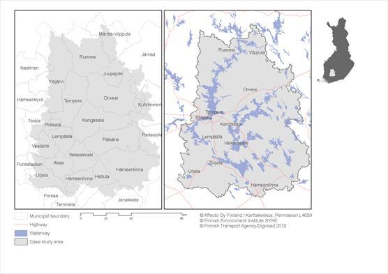
The project approaches the issue of GI at different scales, both nationally and regionally. A case study will be conducted to explore the GI at the regional level. The case study area consists of three catchment areas within the Kokemäenjoki watershed (see the map below). The case study will focus on developing a GIS-based tool for spatially identifying and mapping GI. The method aims to identify the key areas of GI by comprehensively assessing the prerequisites for provision of a multitude of ecosystem services. The analysis rests upon up-to-date and extensive GIS datasets, based on which the spatial variation in ecosystem service provision potential can be estimated within the area of interest, and eventually taken into account in regional land use planning. In addition to the spatial mapping method, the drivers of GI change as well as possibilities to develop national policies to protect and enhance the GI will be identified together with stakeholders in the case study area. The conclusions of the case study will be combined with the other analysis in the project, and generalized to apply at the national level.
Steering group
Jukka-Pekka Flander, Martin Forsius, Jukka-Pekka Jäppinen, Eeva Primmer, Tarja Söderman and Jukka Similä
Contact information
Jukka Similä, Finnish Environment Institute, firstname.surname@ymparisto.fi