The aim of VESISEN projects was to develop methods for utilizing EU Copernicus Programme's Sentinel-2 satellite observations, or Earth Observation data (EO), for monitoring water quality on Finnish lakes and on the coastal waters of Finland. Since 2016 there have been a total of 4 projects (Vesisen I-IV). During the projects it was defined how efficiently EO can be utilized for monitoring water quality parameters for EU directive reporting, such as the Water Framework Directive, and the processing of satellite observation was further developed. Advantage of EO are the large quantity of observations which provide wide spatial and temporal coverage of measurements. The aim of developing the processing methods was to increase the coverage of monitoring especially on areas where in-situ monitoring data was insufficient.
After the first VESISEN project, it was determined from which Finnish water areas the most important water quality variables can be reliably interpreted using EO. Additionally, the average accuracy of interpretations was defined for each water quality variable. During the VESISEN II project (2017–2018), the first testing datasets were processed, and based on the results of the VESISEN I&II projects, EO based water quality monitoring using the Sentinel series satellites was initiated for the Finnish lakes and the Baltic Sea.
In 2024, the interpretation and processing methods used for past six years were updated in the Vesisen III and IV projects to meet with current developments and requirements of the fourth Water Framework Directive. The accuracy of the methods was particularly improved in lake areas, and new lake water formations were included as part of the automated data processing.
The data developed and produced in the Vesisen projects is stored in Syke's Status database, both from water formations and partly from monitoring stations defined by environmental administration. This data is distributed via Syke's open web map interface, the Tarkka service (tarkka.syke.fi). Environmental administration experts can view and analyze the data with Tarkka's analysis-section, as well as summary in the Pisara-interface for chlorophyll-a.
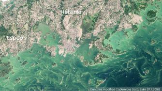
The most interesting satellites regarding water quality monitoring are the Sentinel series Sentinel-2 (S2) and Sentinel-3 (S3). The utilization Copernicus Programme's EO data to monitor water bodies required national research collaboration especially in the beginning of the project 2016-2017. The first of the four S2-satellites was launched in June 2015. This began the era of high resolution (10-60m) MSI (sentiwiki.copernicus.eu) instrument. The first S3-series satellite S3A, was launched in February 2016 with an OLCI (sentiwiki.copernicus.eu) instrument. The OLCI is suitable for daily monitoring of the Baltic Sea and large Finnish lakes, especially regarding chlorophyll-a measurements. S3 satellite also includes a SLSTR (sentiwiki.copernicus.eu) instrument to monitor surface temperatures. The SLSTR-instrument enables monitoring the Baltic Sea and the large Finnish lakes a little bit better than before.
NASA's Landsat series currently operating satellites, LC8 and LC9, OLI (usgs.gov)-instrument is mainly suitable to monitor the turbidity and Secchi depth of water. Also, Syke is providing useful high resolution (100m) water surface temperature data with Landsat's TIRS ()-instrument.
Sub-tasks of the project
The first Vesisen project consisted of algorithm development, validation, and utilization of various types of field observations. The project utilizes especially flow-through measurements systems both on coastal vessels and autonomous Alg@line observations onboard ships-of opportunity. Furthermore, the routine monitoring station observation dates are optimized according to S2A overpasses to obtain match-ups. This matching observation dates were used to validate and develop processing methods. The project focused especially on the EO algorithm functionality at high concentrations and on optically extreme conditions, focusing on the relevant parameters considering the Water Framework Directive: chlorophyll-a, turbidity, Secchi depth, and CDOM absorption. The maintenance of automated station at lake Pyhäjärvi in Säkylä was part of the project.
Instruments used in the projects
- S3 OLCI (sentiwiki.copernicus.eu) (Ocean and Land Color Instrument)
- S2 MSI (sentiwiki.copernicus.eu) (MultiSpectral Instrument)
- LC8 OLI (usgs.gov) (Operational Land Imager)
- SLSTR (sentiwiki.copernicus.eu) (Sea and Land Surface Temperature Radiometer)
The project concentrated on determining the accuracy of various bio-optical models, but also the accuracy of most suitable band ratio algorithms was evaluated especially on eutrophic lakes. The project also focused on automated elimination of errors in the end-products, such as accurate detection of cloudy areas, areas covered by cloud shadows and shallow areas with influence from the seabed. Whitecaps and ships are identified and eliminated from the water quality estimates of S2/MSI.
The optical properties of Finnish lakes and estuaries along the coast are unique. Therefore, 4 field campaigns were utilized e.g. the flow-through measurement system by Luode Consult Oy and optical instruments (ASD and BB3).
Connections to other projects
VESISEN project are relevant with previous research project considering water quality monitoring. Syke has a vast project cluster with external funding focusing on water quality monitoring with EO. Some of the projects are focused on developing new methods and research, which are often part of international research consortiums. Meanwhile, some of the projects are focused on developing the processing methods and improving data distribution adapting to the rapid development of the EO field. The distribution of Syke's EO data is mainly via Tarkka interface. The current project SYTYKE and former project CorEO focused mainly in developing more efficient processing methods. The Tarkka interface has been developed especially with the SYTYKE project, but also with the support of external, international project fundings. The international projects, such as BalticAims I-II, LandSeaLot, Obsgession, SeaLabio, and FPCUP (FPCUP, EO FP CUP water) have focused on developing the processing methods and providing relevant datasets to users.
More information
Senior Researcher, group manager Jenni Attila, Syke, first name.last name@syke.fi
Scientific publications
- Simis SGH, Ylöstalo P, Kallio KY, Spilling K11, Kutser T (2017). Contrasting seasonality in optical-biogeochemical properties of the Baltic Sea. PLoS ONE 12(4): e0173357. https://doi.org/10.1371/journal.pone.0173357
- Ligi, M., Kutser, T., Kallio, K., Attila, J., Koponen, S., Paavel, B., Soomets, T., Reinart, A., (2017). Testing the performance of empirical remote sensing algorithms in the Baltic Sea waters with modelled and in situ reflectance data. Oceanologia, Oceanologia 59: 57—68.
- Kallio, K., Koponen, S., Ylöstalo, P., Kervinen, M., Pyhälahti, T., Attila, J.,(2015). Validation of MERIS spectral inversion processors using reflectance, IOP and water quality measurements in boreal lakes. Remote Sensing of Environment 157: 147–157.
- Ylöstalo, P., Kallio, K. & Seppälä, J. (2014). Absorption properties of in-water constituents and their variation among various lake types in the boreal region. Remote Sensing of Environment 148: 190–205.
- Attila, J., Koponen S., Kallio, K., Lindfors, A., Kaitala, S., Ylöstalo, P. (2013). MERIS Case II water processor comparison on coastal sites of the northern Baltic Sea. Remote Sensing of Environment 128: 138–149.
- Kallio, K. 2012. Water quality estimation by optical remote sensing in boreal lakes. Monographs of the Boreal Environment Research no. 39: 1-54. https://helda.helsinki.fi/handle/10138/39326
- Lepistö, A., Huttula, T., Koponen, S., Kallio, K., Lindfors, A., Tarvainen, M. & Sarvala, J. (2010). Monitoring of spatial water quality in lakes by remote sensing and transect measurements. Aquatic Ecosystem Health & Management 13(2): 176-184.
- Kallio, K., Attila, J., Härmä, P., Koponen, S., Pulliainen, J., Hyytiäinen, U.-M. & Pyhälahti, T. (2008). Landsat ETM+ Images in the Estimation of Seasonal Lake Water Quality in Boreal River Basins. Environmental Management 42: 511-522.
- Koponen, S., Attila, J., Pulliainen, J., Kallio, K., Pyhälahti, T., Lindfors, A., Rasmus, K., Hallikainen, M., (2007). A case study of airborne and satellite remote sensing of a spring bloom event in the Gulf of Finland. Continental Shelf Research 27 (2): 228-244.
- Attila, J., Pyhälahti, T., Hannonen, T., Kallio, K., Pulliainen, J., Koponen, S., Härmä, P., & Eloheimo, K. (2008). Analysis of turbid water quality using airborne spectrometer data with a numerical weather prediction model-aided atmospheric correction. Photogrammetric Engineering and Remote Sensing 74 (3): 363–374.
- Kallio, K., (2006). Optical properties of Finnish lakes estimated with simple bio-optical models and water quality monitoring data. Nordic Hydrology, 37 (2), 183–204.
- Kallio, K., Pulliainen, J., & Ylöstalo, P. (2005). MERIS, MODIS and ETM channel configurations in the estimation of lake water quality from subsurface reflectance with semi-analytical and empirical algorithms. Geophysica 41: 31-55. (pdf, 530 kB)
- Kutser, T., Pierson, D. C., Kallio, K. Y., Reinart, A. & Sobek, S. (2005). Mapping lake CDOM by satellite remote sensing. Remote sensing of Environment 94: 535-540.
- Kutser, T., Pierson, D., Tranvik, L., Reinart, A., Sobek, S. & Kallio, K. (2005). Estimating the colored dissolved organic matter absorption coefficient in lakes using satellite remote sensing. Ecosystems 8: 709-720.
- Vepsäläinen, J., Pyhälahti, T., Rantajärvi, E., Kallio, K., Pertola, S., Stipa, T., Kiirikki, M., Pulliainen, J. & Seppälä, J. (2005). The combined use of optical remote sensing data and unattended flow-through fluorometer measurements in the Baltic Sea. International Journal of Remote Sensing 26 (2): 261-282.
- Pulliainen, J., Vepsäläinen, J., Kaitala, S., Hallikainen, M., Kallio, K., Fleming, V., Maunula, P. (2004). Regional Water Quality Mapping through the Assimilation of Space-Borne Remote Sensing Data to Ship-Based Transect Observations. Journal of Geophysical Research, Vol. 109, No. C12, C12009.
- Koponen, S., Kallio, K., Pulliainen, J., Vepsäläinen, J., Pyhälahti, T., Hallikainen, M. (2004). Water Quality Classification of Lakes Using 250-m MODIS Data. IEEE Geoscience and remote sensing letters 1(4): 287-291.
- Kallio, K., Koponen, S., Pulliainen, J., (2003). Feasibility of airborne imaging spectrometry for lake monitoring—a case study of spatial chlorophyll a distribution in two meso-eutrophic lakes. International Journal of Remote Sensing 24 (19): 3771–3790.
- Härmä, P., Vepsäläinen, J., Hannonen, T., Pyhälahti, T., Kämäri, J., Kallio, K., Eloheimo, K., Koponen, S. (2001). Detection of water quality using simulated satellite data and semi empirical algorithms in Finland. The Science of Total Environment 268 (1-3): 107-121.
- Kallio, K., Kutser, T., Hannonen, T., Koponen, S., Pulliainen, J., Vepsäläinen, J., Pyhälahti, T. (2001). Retrieval of water quality from airborne imaging spectrometry of various lake types in different seasons. The Science of Total Environment 268 (1-3): 59-77.
- Koponen, S., Pulliainen, J., Servomaa, H., Zhang, Y., Hallikainen, M., Kallio, K., Vepsäläinen, J., Pyhälahti, T., Hannonen, T. (2001). Analysis on the feasibility of multi source remote sensing observations for chl a monitoring in Finnish lakes. The Science of the Total Environment 263(1-3): 95-106.
- Kutser, T., Herlevi, A., Kallio, K. & Arst, H., (2001). A hyperspectral model for interpretation of passive optical remote sensing data from turbid lakes. The Science of the Total Environment 268: 47-58.
- Pulliainen, J., Kallio K., Eloheimo, K., Koponen, S., Servomaa, H., Hannonen, T., Tauriainen, S., Hallikainen, M. (2001). A semi-operative approach to water quality retrieval from remote sensing data. The Science of The Total Environment 268: 79-93.
Other publications
- Koponen, S. ja Attila, J., Sentinel-satelliitit mullistavat vesiseurannan, Vesitalous 2/2017, pp. 16-19.
- Attila, J., Alasalmi, H., Bruun, E., Kallio, K. ja Räike, A. 2016. Jokivesien sameusalueet rannikolla vuosien 2003 -2015 satelliittikuvista arvioituna. 12 s. (pdf, 2842 kB)