
Project description
European directives such as the Water Framework Directive and Marine Strategy Directive require member states to reach good ecological status in their coastal and inland waters. In the Baltic Sea this goal has not yet been achieved.
Spatial planning is a process that aims for the mitigation of the impacts of human activities and eventual improvement of the state of the environment through coordination and implementation of various practices and policies. Thus, one important action for the improvement of the state of the Baltic Sea is to improve the territorial and maritime spatial planning capabilities of the organizations operating in the area. Our goal was to develop an integrated data approach to obtain a full view of the essential processes of land and coastal water areas by combining various currently available satellite data sources, in situ observations and model predictions about dynamic landcover and water quality characteristics.
The BalticAIMS project reached this goal through the following technical objectives:
- Identify suitable environmental data and GIS materials.
- Integrate, process and store thematic information.
- Create the data access, visualization and analysis systems and tools.
The relevance of the Marine Spatial Planning techniques supported by EO to assess changes in environment due to agriculture, land use, aquaculture and changes in runoff have now been demonstrated for selected areas in Finland, Sweden, Germany and Poland. See the Service access and D4.1 (pdf, eo.ymparisto.fi) for more details.
The project has now concluded the service uptake and utility analysis and the definition of the roadmap for further service provision in a Baltic Sea wide scope (WP5). These results are reported in D5.1 Service Utility Report (pdf, eo.ymparisto.fi). The main results of the project are summarized in a newsletter (pdf, eo.ymparisto.fi).
The 1st phase of the project ended after the Final Review meeting held on April 19, 2023. In early September 2024 ESA granted the project new funding which allowed us to extend the service development and provision for 18 months. We followed the roadmap outlined in D5.1 Service Utility Report (eo.ymparisto.fi) by adding more service areas, use case examples and technical elements. We also demonstrated a service where ICEYE (iceye.com) SAR data is used for sea ice monitoring in the Baltic. The second phase was concluded on Apr 29, 2026. See below for results from both phases.
The project is under ESAs EO4society programme (eo4society.esa.int) (contract number 4000133565/20/I-NB) and part of the Baltic Regional Initiative activities (eo4society.esa.int). The project is supported by ESA Network of Resources Initiative. It is also linked to the Baltic Earth community.
Workplan and deliverables
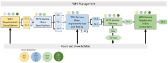
The following schematic shows the work packages of the project and the interaction between them and the users and stakeholders.
WP Schedule of the extension (2024 to 2026)
The kick-off of the extension was in Sep. 2024. Below is the final schedule of the WPs.
WP3 Service Chain Implementation and Testing: Sep. 2024 – June 2025 (closed)
WP4 Service Delivery: Sep. 2024 – Mar. 2025 (closed)
WP5 Service Uptake and Utility Assessment: June 2025 –Apr. 2026 (closed)
WP6 Management: Sep. 2024 – Feb. 2026 (closed)
The deliverable documents and other results of the project were made available once approved by ESA. In addition to the deliverables some examples about how to use the systems were compiled into this BalticAIMS presentation (pdf, sykedata.ymparisto.fi).
| Deliverable ID | Title | Event | Delivery Date to ESA |
| D3.3 | Service System Update Report (pdf, sykedata.ymparisto.fi) | MTR | 06/2025 |
| D4.2 | Service Operations and Service Chain Performance Report Update (pdf, sykedata.ymparisto.fi) | SOR | 03/2026 |
| D5.2 | Service Utility Report Update (pdf, sykedata.ymparisto.fi) | FR | 04/2026 |
| Final Report (pdf, sykedata.ymparisto.fi) | FR | 04/2026 |
MTR = Mid Term Review, SOR = Service Operations Review, FR = Final Review.
WP Schedule of the 1st phase (2021 to 2023)
The project kick-off was in Feb. 2021. The Final Review meeting took place in Apr. 2023. Below you can find the final schedule of the WPs.
WP1 Requirements Consolidation: Feb. 2021 – May 2021 (closed, see the deliverables below)
WP2 Service Chain Specification: May 2021 – Sept. 2021 (closed, see the deliverables below)
WP3 Service Chain Implementation and Testing: Sept. 2021 – Mar. 2022 (closed, see the deliverables below)
WP4 Service Delivery: Apr. 2022 – Nov. 2022 (closed, but the services are kept online until Feb. 2023, see the deliverables below)
WP5 Service Uptake and Utility Assessment: Jul. 2022 – Feb. 2023
Baltic Workshop was held on Jan. 19, 2023 as a side event of the Finnish Satellite Workshop 2023
WP6 Management: Feb. 2021 – Apr. 2023
The deliverable documents and other results of the project were made available through the links in the table below once approved by ESA.
| Deliverable ID | Title | Evevt | Delivery Date to ESA |
| D1.1 | User Segmentation and Operational Practices Review (pdf, eo.ymparisto.fi) | PM1 | 04/2021 |
| D1.2 | User Requirements Specification (URS) (pdf, eo.ymparisto.fi) | PM1 | 04/2021 |
| D2.1 | Service Portfolio Definition (pdf, eo.ymparisto.fi) | PDR | 09/2021 |
| D2.2 | Data and Platform Provisioning Plan (pdf, eo.ymparisto.fi) | PDR | 09/2021 |
| D2.3 | Service Delivery Chain Specification (pdf, eo.ymparisto.fi) | PDR | 09/2021 |
| D3.1 | Service Chain Verification Report (SVR) (pdf, eo.ymparisto.fi) | SRR | 03/2022 |
| D3.2 | System and Service Chain Readiness Report (SRR) (pdf, eo.ymparisto.fi) | SRR | 03/2022 |
| D4.1 | Service Operations and Service Chain Performance Report (pdf, eo.ymparisto.fi) | SOR | 11/2022 |
| D5.1 | Service Utility Report (pdf, eo.ymparisto.fi) | FR | 04/2023 |
| Final Report (pdf, eo.ymparisto.fi) | FR | 04/2023 |
PM =Progress Meeting, PDR = Preliminary Design Review, SRR = System Readiness Review, SOR = Service Operations Review, FR = Final Review.
Service access
The Service Delivery phase (WP4) of the BalticAIMS project has officially ended but the service provision is continued while the project extension is being negotiated. Access to EO, in situ, GIS and model data is provided in three ways:
- Tarkka (Tarkka.syke.fi) is an updated version of Syke’s TARKKA service. In the BalticAIMS project it is used as a public user interface for information related to the user stories. Tarkka is also being developed for other purposes and will, in time, replace the current TARKKA.
- The BalticAIMS xcube viewer (viewer.balticaims.eu/) provides access to the EO and model data stored in the xcube.
- The data in the backend systems (xcube and GeoDB) can be accessed directly with desktop applications such as QGIS. The servers are also listed in the BalticAIMS infrastructure (balticaims.eu).
Examples of the implemented user stories are described in D4.1 Service Operations and Service Chain Performance Report (pdf, eo.ymparisto.fi).
Partners
Finnish Environment Institute (Syke) under the Finnish Ministry of Environment, is a government research institute, and a center for environmental expertise. Syke's research focuses on changes in the environment and seeks ways to control these changes. Syke conducts research on wide range of fields, from environmental policy, state of natural environment, climate change, marine and freshwater environments, to the cryosphere. A strong focus is on multi-disciplinary work and providing information, skills and services to achieving sustainable development in Finland and globally. The information produced in research and operational services are served to customers ranging from researchers in environmental administration and universities to governmental and municipal authorities as well as common citizens.
Syke is responsible for the overall coordination of the project. In addition, Syke leads Requirements Consolidation (WP1) and Service Chain Specification (WP2).
Brockmann Consult GmbH (BC) (brockmann-consult.de) is a private Brockmann_Consult_logocompany offering services for the management of environmental data in particular from Earth Observation. The company comprises two complementary branches: The Environmental Informatics Department and the Geo-Information Services Department. The company has 30 staff members and is located in Hamburg, Germany.
BCs main role in the project is lead the Service Chain Implementation and Testing (WP3) and Service Delivery (WP4).
Brockmann Geomatics (BG) (brockmann-geomatics.se) is a private Brockmann_Geomatics_logocompany of geoinformatic consultants, offering services comprising information products and methodological solutions, based on remote sensing and GIS technology, with focus on natural objects with high conservation value. The company was established in March 2011 but the personnel are experienced remote sensing, GIS and environmental specialists with vast experience in the field. BG has five employees of which four have doctorates.
BG leads the Service Uptake and Utility Assessment (WP5).
Klaipeda University (KU) (ku.lt) Klaipeda University logois a multidisciplinary university engaged in research and education to sustain the development of the western region of Lithuania. Its Marine Research Institute conducts fundamental and applied studies on marine environments and maritime technologies, with well-established research groups, including one specializing in Earth Observation and remote sensing for environmental investigations. In the project KU acts as a link to the user community in Lithuania especially concerning the Curonian Lagoon.
Finnish Meteorological Institute (FMI) (en.ilmatieteenlaitos.fi) makes FMI logo observations and research on the atmosphere, the near space and the seas. It also provides services on weather, sea, air quality, climate and near space for the needs of public safety, business life and citizens. The Finnish Meteorological Institute is an administrative branch of the Ministry of Transport and Communications. FMI’s main role in the project is to demonstrate a service where ICEYEY (iceye.com) SAR data is used for sea ice monitoring in the Baltic.
Internal (workspace)
The password protected workspace for the project (fse.eduuni.fi)
Current
- In early September 2024 the project funding was extended for 18 months. New information about the extension will be made available soon.
- A newsletter (pdf.eo.ymparisto.fi) summarizing the main results of the project has been published
- The results of WP 5 were reviewed at the Final Review meeting on Apr 19, 2023. The deliverables are available in the Workplan and Deliverables page
- On Jan. 19, 2023 the project organized a workshop where the results were presented and the service utility was discussed. The results will be reported in D5.1 Service Utility Report
- The results of WP 4 were reviewed on Nov. 10, 2022. The deliverables are available in the Workplan and Deliverables page
- The results of WP 3 were reviewed on Mar. 31, 2022. The deliverables are available in the Workplan and Deliverables page
- The results of WP 2 were reviewed on Sept. 23, 2021. The deliverables are available in the Workplan and Deliverables page
- The results of WP 1 were reviewed on May 4, 2021. The deliverables are available in the Workplan and Deliverables page
- The project was kicked off on Feb. 23, 2021