5.1.1 Basic information requirements
Basic information of any IM site must be given when it is entered into the monitoring network of the programme. The mandatory information consists of:
- Country code (ISO alpha-2, see Annex 4)
- Number of the site (running per country)
- Name of the site
- Geographical coordinates (latitude, longitude, accuracy of minutes)
- Maximum elevation (m.a.s.l), highest point
- Minimum elevation (m.a.s.l), lowest point
- Political jurisdiction (state or province)
- County (smallest administrative region)
- Owner type (state, communal or private)
- Size of the site (ha)
- Water area (% of total)
- Dominant soil type
- Dominant vegetation (including tree stands)
- Long-term average precipitation (mm), last 30 year period
- Long-term average temperature (?C), last 30 year period
- Snow (%), percentage estimate of precipitation
- Length of the hydrological cycle (days/year), free water flow
- Length of the vegetation period (days/year), mean temperature > 5 ?C for 5 consecutive days
- Land-use history
- Earlier investigations
- Anthropogenic stresses to the site (e.g. siting of nearby industry or agriculture, recreation pressure, pasture of sheep etc.)
The above information can be given in free format or using the Site Description form (Annex 5).
Additional information is needed for the calibration of models. These data include detailed information on vegetation and physical as well as chemical characteristics of the soil. Some of the necessary values are not collected regularly, but might exist from local model runs or special investigations carried out at the site. The models have quite different data requirements to the normal IM monitoring, and a variety of information may be needed. Such information will be sought directly by the modeller from the National Focal Points.
5.1.2 Mapping
The aim of mapping the monitoring site is to provide the basis for choosing the most representative locations for various types of sampling and to provide the basis for scaling the monitored information up to the site scale.
|
|
| |
|
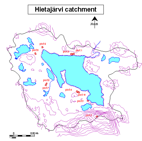
Figure 5.1 Base map of site FI03 Hietajärvi showing the location of permanent plots and measurement stations
|
If no maps are available for the site, they should be prepared using standard mapping techniques. Site maps are a mandatory part of the IM programme. The maps produced should be sent to the Programme Centre. Digital maps can be sent via E-mail or on diskettes or CDs, preferably in ARC/INFO export-format. Good paper maps are also acceptable and should always be provided. Please enclose information about the coordinate systems used on the maps.
The Focal Points are responsible for ensuring that no copyright restrictions on maps are violated.
5.1.2.1 Base map
A base map of each IM site should be produced in scale 1:2 000-1:10 000, on which contours, streams and lakes are marked. The catchment/monitoring site should be outlined on the map and reference coordinates should be marked. If a digital elevation model of the IM site is available, this should also be sent to the Programme Centre.
All stations (permanent plots, observation sites, groups of trees used for measurements etc.) should be marked on the map (Figure 5.1). Stations are identified by station code, institute and subprogramme (see chapter 5.3.1). The same station code should be used for different subprogrammes when the measurements are carried out in the same plots or close to one another on the same habitat. Additional information concerning the stations should be available from NFPs upon request.
5.1.2.2 Bedrock
A geological map of the site should be provided, detailing at least the main rock types (Figure 5.2). This information is needed for estimating site weathering patterns.
Figure 5.2 Bedrock of Pesosjärvi (FI04) IM site.
5.1.2.3 Soil material
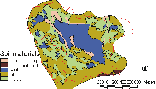
An overburden map of the site should provide information on at least the most important soil materials (e.g. peat, sand, loess), see Figure 5.3.
|
|
|
|
|
Figure 5.3 Map of soil material from Hietajärvi (FI03) IM site.
|
|
|
|
|
|
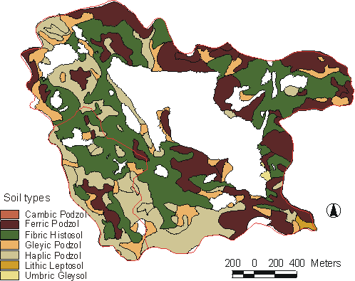
Figure 5.4 Soil type map of Hietajärvi (FI03) IM site.
|
5.1.2.4 Soil types
If no pedological map of the site exists, a pedological survey should be carried out. National pedogenic classifications should be annotated with the equivalent FAO soil units (Figure 5.4) (FAO UNESCO 1990. Soil map of the world. Revised legend, World Soil Resources Report 60. Rome 1990).
Each soil unit on the map should have the following information: humus form (mor, moder, mull) and thickness, soil texture (by hand, soil texture triangle), and soil depth (depth to bedrock) class (e.g. <1m, 1<>3m, >3m). Soil chemistry data (recommended: heavy metals, pH, TOC, CEC_E and BASA) is optional. This information, which can be obtained using systematic sampling or judgement sampling, is very useful for scaling-up results to the catchment and for catchment-scale modelling.
5.1.2.5 Plant communities
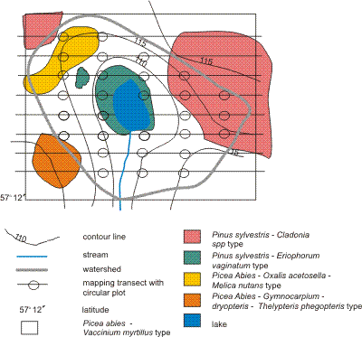
The plant communities, delimited at about the level of the Braun-Blanquet association or equivalent, are mapped (Figure 5.5) using standards relevant in the country. The mapping could preferably be performed using the permanent network of lines established for vegetation and soil surveys and monitoring of tree bioelements and tree population dynamics.
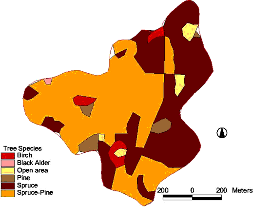
5.1.2.6 Tree stands
Tree stands are mapped (Figure 5.6) according to relevant standards in the country. Preferably use the permanent lines as under Plant communities (Figure 5.5). Separate the stand types by visual inspection of dominant tree species, dominant height, layering, number of stems per unit area and development class.
Development classes:
0 = open area
1 = one age class; young, developing forest stand (trees <1.3 m)
2 = one age class; young, developing forest stand (trees >1.3 m)
3 = one age class; mature forest stand
4 = one age class; old, degenerating forest stand
5 = two age classes; young and mature or young and old forest stand (100 trees/ha of old generation)
6 = two age classes; mature and old forest stand (100 trees/ha of old generation)
7 = not possible to classify in classes 1-6
If required, the visual inspection may be supplemented with measured quantitative information such as basal area, tree heights, number of stems alive and dead, number of windthrown stems etc., preferably collected on sample plots (subprogramme BI).
|
|
|
|
|
Figure 5.5 Example of a base map with distribution of plant communities.
|
|
|
|
|
|
Figure 5.6 Forest stand map (dominating tree species) of Zemaitija (LT03) catchment.
|
5.1.3 Inventories
In connection with the assessment of biodiversity, inventories of plant and animal species at the site may be extremely useful. These should be maintained as species lists for each functional or taxonomic group (e.g. vascular plants, Lepidoptera etc.). Information on abundance will enhance the value of such lists. This information should be held at the National Focal Points. However, the IM Programme Centre should be informed about the availability of such data for particular sites. An example how to carry out the inventories are given in 5.1.3.1 Plant species inventory and in subprogramme VS, Vegetation structure and species cover.
Inventories of soil properties (e.g. field surveys of horizon thickness and texture) are important for modelling studies. Samples can be taken optionally for the analysis of soil chemical properties. Data should be held at National Focal Points and the IM Programme Centre informed of its availability.
5.1.3.1 Plant species inventory (optional)
The aim is to give the full plant species list with or without abundance of each species of the whole site irrespective of plots. The inventory could either include both soil-living plants and epiphytes or only the former. An inventory of plants on all substrates is especially valuable when biodiversity is in focus.
Method Species lists with or without abundance are prepared for soil-living plants per plant community and/or, for epiphytes, per type of substrate, e. g. mineral surfaces, tree trunks, branches, logs, dead wood, other understorey plants. Note that abundance in this case refers strictly to the number of individuals or shoots, not cover or dominance, and that each species is estimated independently from the others.
Abundance classes (Braun-Blanquet 1965):
1=very sparse
2=sparse
3=not numerous
4=numerous
5=very numerous
The survey is done initially and then repeated after major changes in the vegetation by, e. g. management measures, grazing, fire, windthrow and landslide. The season for the inventory of vascular plants should coincide with maximum development of vegetative and reproductive organs of most species in order to make the identification easy.
Parameters to be stored Plant community names are recorded in extenso. They should refer to community types established and commonly used in the country, e. g. the Braun-Blanquet communities (Braun-Blanquet 1965) or the Nordic vegetation types (Påhlsson 1994) or communities used in the framework of EU Corine Land Cover (Cruickshank & Tomlinson 1996). Relevant substrate types are recorded with free names, but as far as possible the species names of tree substrates should be given.
PRESENCE/ABUNDANCE of soil-living species per community PRESENCE/ABUNDANCE of epiphytes per substrate
References
Braun-Blanquet, J., 1965: Plant Sociology; the study of plant communities (Transl. rev. and ed. by C.D. Fuller & H.S. Conard). Hafner, London.
Cruickshank, M.M. & Tomlinson, R.W., 1996: Application of CORINE land cover methodology to the U. K.: Some issues raised from Northern Ireland. -Global Ecology and Biogeography letters 5:235-248.
Påhlsson, L. (ed.), 1994: Vegetationstyper i Norden (Vegetation types in the Nordic countries). Tema Nord 1994:665. (In Swedish with introductions in Finnish, Icelandic and English.)