7.7.1. Introduction
Of the three environmental changes given the highest priority within the IM programme (see Chapter 2), only N and S deposition have implications for the soil chemistry subprogramme (the third, increasing atmospheric O3 concentrations, can be expected to have little impact on soils, at least directly). Heavy metal pollution, which may be locally very important in terms of soil chemistry and ecotoxicological effects, has been given optional status only. The minimum requirements of the SC subprogramme therefore reflects the acidification impacts of S and N deposition, and the eutrophication impact of N deposition.
The parameters in the minimum SC subprogramme necessary for the relevant cause/effect relationships and for modelling (Table 7.7.1) include:
- those properties describing the acid and N status of the soil, e.g. pH, CEC, BS, N, base cation concentrations. These represent the parameters for monitoring soil quality per se,
- those background properties that largely determine soil acidity and nutrient status, i.e. organic matter content (OM) and particle size distribution (PSA). The soil quality parameters listed under i) above are strongly dependent on OM and PSA and therefore important in the interpretation of the soil quality parameters listed under point 1.
- those parameters necessary for calculating soil chemistry pools/amounts, i.e. bulk density (BDEN) and stone content (SCONT). These parameters are required for making mass balance budgets of the soil quality parameters.
- those soil properties/variables required by the various acidification and geochemical models that will be used within the IM programme, e.g. soil mineralogy (for weathering), parent material type, sulphate adsorption, nitrification rates, soil water retention characteristics.
It is important to distinguish between those soil parameters which are part of a routine monitoring programme describing soil quality (i.e. point 1. above ) and those additional parameters which enable either interpretation or wider use of the soil quality data. The relationships between soil quality parameters can be correlated with parameters from both within the SC subprogramme and from other subprogrammes. When the IM Programme Centre carries out modelling exercises, the NFPs will be contacted concerning the availability of data and parameters.
7.7.2. Methods
7.7.2.1. Field methods - Sampling
Principles
Because it is essential that the IM data is comparable in both time and space, it is better to sample the mineral soil by fixed depth soil layers rather than pedogenic horizons for monitoring purposes (but humus layer must be sampled separately). The arrangement of soil horizons varies spatially - not all the IM SC plots will have an E horizon, for example, and the thicknesses of the same horizon varies from site to site, making it difficult to compare soil nutrient pools. Since soil horizons and their mutual arrangement are the result of soil development processes, horizons have different properties. Therefore, the use of fixed depth layers may be criticised because a fixed depth layer may contain soil from more than one pedogenic horizon.
Nevertheless, as the SC plot should be as homogeneous as possible with respect to soil type and parent material, a fixed depth layer of the mineral soil would consist of the same soil material each time, and therefore be comparable between sampling occasions. Also, since all SC plots would have a 0-5 cm layer, for example, this layer can be compared directly between plots and IM sites (NB. 0=top of mineral soil). Finally, the amount of N in the 0-20 cm layer, for example, can be computed and compared directly among all SC plots and IM sites. For these reasons, it is recommended to use fixed depth layers in the minimum SC monitoring subprogramme.
However, a soil profile description should be made at the plot and samples taken by pedogenic horizon for classification and characterisation purposes. Also, the soil parameters required by relevant simulation models usually refer to soil horizons. This reflects the process orientation of such models. Such sampling need only be done once and from a single soil pit at each SC plot.
Permanent SC plot and sampling design
A permanent homogeneous SC plot of the order of 40 x 40 m, its size depending on the heterogeneity of the site, should be established (see Chapter 5.2). This SC plot should be located close to, but not coinciding with, the VG monitoring plot. The sampling procedure should abide by the following principles: it should be systematic, cover the whole soil plot each sampling occasion, and to include an adequate number of subsamples so as to give sufficient precision as to allow possible changes over time (decades) to be detected. A record of the places sampled should also be recorded, so that they will not be resampled at a later date.
An example of a SC plot and its sampling is shown in Figure 7.7.1. It is divided into 10 x 10 m subplots, which are further divided into 1 x 1 m subplots. A soil sample is taken from one of the 1 x 1 m subplots, which have not been used earlier or rejected because of logs, boulders, large roots etc., in each of the 10 x 10 m subplots so that the entire soil plot is covered. In the example, 16 10 x 10 m subplots are thus sampled.
Compositing
In order to reduce the number (and costs) of samples for analysis, soil samples are often composited. Compositing all the samples into a single sample for analysis, however, means that there is no information about the within-plot variability with which to test for significant differences and calculate confidence limits. A number of compositing strategies can be used to obtain a limited number of samples for analysis while still retaining information about variability. For example, each of the samples can be analysed individually on at least one sampling occasion to determine a reference variability value and samples taken on subsequent sampling occasions bulked (Fig. 7.7.2 a); a limited number (3-4) of parallel samples can be taken at each sampling point, each of the parallel samples being composited over the entire plot (Fig. 7.7.2 b); individual samples taken at each sampling point can be composited on a random basis into 3-4 samples for the plot ( Fig. 7.7.2 c).
Sampling timetable
Sampling should be carried out approximately every 5th years, each time at the end of the growing season in August-October. Sampling could be synchronised with other IM subprogrammes and EU European Programme for the Intensive Monitoring of Forest Ecosystems (Haussmann 1995) sampling timetable:1995, 2000, 2005.
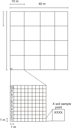
Figure 7.7.1 An example of a SC plot and its sampling.
Sampling procedure
The humus layer should be sampled separately with a cylinder (steel or some other such inert material) of known diameter. The sample should include only the Of+Oh organic layers, i.e. the green and litter (Ol) material should be excluded. Record thickness of each humus sample so that bulk density (BDEN) can be calculated. Humus form (mor, moder, mull) should also be recorded.
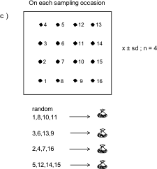
Figure 7.7.2 a-c. Compositing strategies in SC sampling.
It is recommended that the following mineral soil layers are sampled: 0-5 cm, 5-10 cm, 10-20 cm, 20-40 cm, 40-80 cm. These layers are those advised in the ICP Forests Level II programme (ICP Forests 1994,1997) and are to be used within the EU European Programme for the Intensive Monitoring of Forest Ecosystems (Haussmann 1995). However, for those countries that have already started an IM SC subprogramme, it may be preferable to continue using the original SC recommended layers: 0-5 cm, 5-20, 20-40 and 60-80 cm or C horizon material (EDC 1993). In order to minimise disturbance, it is recommended to use a soil auger to take the samples. However, it may be difficult to take a sample from the deeper layers directly with an auger and some excavation may be necessary. Alternatively, only sample those layers that can be adequately sampled from the surface with an auger. If the thickness of a sample is less than a threshold thickness (e.g. 75% of the target thickness of a layer), it is rejected.
The volume of mineral soil samples taken with an auger are usually not accurate enough to allow bulk density to be calculated. Therefore, a set of undisturbed samples of the same layers should be taken for bulk density determination. These samples can be taken from a soil pit dug near to but outside the plot. Alternatively, transfer functions of the type described by Tamminen & Starr (1994) could be used. A sample of the deeper layers that were not possible to sample on the plot with the auger could also be taken from this pit. It is also recommended that a profile description is made from this pit (Table 7.7.3) and a sample of each pedogenic horizon described taken.
Peat samples should be taken from the following depths: 0-5, 5-20 and 20-40 cm. It is relatively easy to take the peat samples volumetrically with a box-type sampler, e.g. 5 x 5 cm. A general description of the peat, including at least humification degree (von Post scale) and peat type (botanical composition), should be made from a profile at a representative point near the plot.
The soil samples should be kept in carefully labelled plastic bags in the dark and cold (+4ºC) until they can be pretreated.
Sample pretreatment
Dry the samples at approximately +40ºC to constant weight as soon as possible after collection. Sieve the samples through a 2 mm mesh (4 mm for organic samples or remove large material: cones, wood pieces etc, by hand). Retain the <2 mm material for analysis. The organic soil samples (humus layer and peat) should be milled into a fine powder. Keep the air-dried samples in dark, cool and dry conditions to await analysis. (Note: If the samples can not be analysed immediately following pretreatment, it is better to store pretreated samples than fresh samples).
7.7.2.2 Laboratory analyses
A list of parameters and codes for the minimum SC subprogramme are given in Table 7.7.1. The methods described in the previous manual (EDC 1993) are still recommended and should be referred to. The corresponding ISO method is also recommended where possible. Use of national method differing from those recommended is strongly advised against. However, if used, then a calibration regression model between the national method and one of the recommended methods is expected by the ICP IM Programme Centre, together with method description. In the original IM methods, 1 M NH4Cl and 1M KCl were recommended as the extractants for the exchangeable chemistry. The use of 0.1 M BaCl2 has a number of advantages however (Hendershot & Duquette 1986):
1) all the exchangeable chemistry can be done with one extractant instead of NH4Cl and KCl,
2) the use of 0.1 M rather than 1M solutions results in less blocking of ICP and AAS burners. However, there is a health risk attached to the use of Ba.
A list of standards is available in Chapter 8.5
The laboratory should be made aware of possible problems with high reagent blanks due to inpurities in reagents.
7.7.3 Quality assurance/Quality control
Each NFP is expected to ensure that good laboratory practice is followed and are responsible for the quality of data reported to ICP IM Programme Centre. The results of quality controls, laboratory intercallibrations etc. undertaken (either with IM samples in particular or of the laboratory in general) should be reported to the IM Programme Centre. The Programme Centre also encourages participation in international soil analysis intercallibration exercises. Any comparisons of national methods deviating from the recommended IM methods that have been made should also be reported.
See data quality management in Chapter 8.
7.7.4 Data handling
Derived SC parameters (see Table 7.7.1) can either be reported directly to the Programme Centre or the Programme Centre can calculate these parameters from the primary parameters.
7.7.5. Data reporting
See Tables 7.7.1 and 7.7.2 for a list of mandatory and optional parameters. An example of reporting mandatory and optional parameters. Profile descriptions will be reported separately.
Table 7.7.1 SC Mandatory (minimum) parameters
|
Parameter
†
|
Code (list)
report also pretreatment!
|
Reporting Units
|
Recommended methods and comments
‡
|
|
Measured:
|
|
|
|
|
pH (CaCl2)
|
PH (DB)
|
pH value
|
Original method (EDC 1993) or ISO/DIS 10390 (ISO-1:5 volume/volume and shaking time 5 min, let stand for 2-24 h before measurement, otherwise similar to original IM method).
|
|
S total
|
STOT (DB)
|
mg/kg
|
Original manual method (EDC 1993).
|
|
P total
|
PTOT (DB)
|
mg/kg
|
Original manual method (EDC 1993); no ISO method
|
|
N total
|
NTOT (DB)
|
mg/kg
|
Original manual method (EDC 1993), ISO 11261 Kjeldahl N or ISO 13878 dry combustion
|
|
Ca exchangeable
|
CA (DB)
|
meq/kg **
|
Original 1M NH4Cl, 1M KCl or 0.1M BaCl2 extraction (EDC 1993) (NB Health risk with Ba)
|
|
Mg exchangeable
|
MG (DB)
|
meq/kg
|
Original 1M NH4Cl, 1M KCl or 0.1M BaCl2 extraction (EDC 1993) (NB Health risk with Ba)
|
|
K exchangeable
|
K (DB)
|
meq/kg
|
Original 1M NH4Cl, 1M KCl or 0.1M BaCl2 extraction (EDC 1993) (NB Health risk with Ba)
|
|
Na exchangeable
|
NA (DB)
|
meq/kg
|
Original 1M NH4Cl, 1M KCl or 0.1M BaCl2 extraction (EDC 1993) (NB Health risk with Ba)
|
|
Al exchangeable
|
AL (DB)
|
meq/kg
|
Original 1M NH4Cl, 1M KCl or 0.1M BaCl2 extraction (EDC 1993) (NB Health risk with Ba)
|
|
TOC
|
TOC (DB)
|
mg/kg
|
Original IM method, LECO Carbon analyser (grinding of <2 mm fraction may be necessary first), ISO/DIS 10694. For non calcareous soils, TOC can be approximated as Loss on Ignition (OM) × 0.58.
|
|
exchangeable titrable
acidity (H+Al)
|
ACI_ET (IM)
|
meq/kg
|
Original 1M NH4Cl, 1M KCl or 0.1M BaCl2 extraction (EDC 1993)
(NB 1. Health risk with Ba. 2. Not possible to to do exchangeable titrable acidity due to Al only.)
|
|
Derived/calculated
§
:
|
|
|
|
|
CEC
|
CEC_E (IM)
|
meq/kg
|
CEC_E is calculated as Ca+Mg+K+Na+ACI_ET (EDC 1993)
|
|
Base Saturation
|
BASA (DB)
|
%
|
BASA is calculated as( (Ca+Mg+K+Na)×100) /CEC_E (EDC 1993)
|
|
Weathering
Explaining:
|
WEA (IM)
|
meq/m2/yr **
|
Base cation weatheringi = outputi - inputi +/- Δstoragei,
where: outputi= stream discharge of element i, inputi = total deposition of element i ,
Δstoragei = vegetation and soil pools of element i. * i=Ca 2+ + Mg 2+
|
|
Dry Bulk Density, <2mm
|
BDEN (IM)
|
kg/m3
|
ISO/DIS 11272 - may need to correct for weight of >2mm fraction. Mineral soil values can be estimated from PSA and organic matter (e.g. Tamminen & Starr 1994). Values for humus layer can easily be determined
|
|
Stone content, >2mm
|
SCONT (IM)
|
m3/m3
|
Profile description, Viro's steel rod penetration method (Viro 1952) ; urgently in need of development
|
|
PSA, <2mm fraction
|
PSA_SAND (IM)
PSA_SILT (IM)
PSA_CLAY (IM)
|
% (sand)
% (silt)
% (clay)
|
Particle size analysis, ISO/DIS 11277. Sand=2000-63 µm, Silt=63-2 µm, Clay< 2 µm
|
†Analysis to be made on air-dried and <2 mm fraction (milled sample in case of peat and forest floor samples). Values to be reported on oven-dry (105ºC) basis (except pH). For pretratment of samples , see ISO/DIS 11464 Soil Quality — Pretreatment of samples for physico-chemical analyses.
‡National methods should be calibrated against the reference IM methods on a representative set of samples and the calibration regression model reported to IM Programme Centre. For Draft ISO/DIS methods, see: ISO Standards Compendium.
Environment. Soil Quality. General aspects; chemical and physical methods of analysis; biological methods of analysis. First edition. 1994. ISBN 92-67-10203-6
§These do not have to be reported as can be calculated by ICP IM Programme Centre. Data already reported to the ICP IM Programme Centre may be used to develop transfer functions for non-reported parameters
* For stable ecosystems, change in storage can be assumed to be 0 (White A.F. & Blum A.E., 1995).
** meq/kg = mmol (+)/kg ;= meq/m2/y = mmol(+)/m2/y
Table 7.7.2 SC Optional parameters
|
Parameter1
|
Code (list)
report also pretreatment code!
|
Reporting Units
|
Recommended methods and comments2
|
|
pH (water)
|
PH (DB)
|
pH value
|
Original method (EDC 1993) or ISO/DIS 10390 (ISO-1:5 volume/volume and shaking time 5 min, let stand for 2-24 h before measurement, otherwise similar to original IM method.)
|
|
exchangeable
Mn, Fe
|
MN, FE (DB)
|
meq/kg **
|
Original 1M NH4Cl, 1M KCl or 0.1M BaCl2 extraction (EDC 1993) (NB Health risk with Ba)
|
|
Trace elements (Pseudo total)
Cd, Pb, Cu, Zn,
Ni, As, Cr, Mo, Hg
|
CD, PB, (DB)
CU,ZN etc.
|
mg/kg
|
Original 7M HNO3 & autoclave at 120ºC (EDC 1993). ISO/DIS 11466 Aqua Regia method - laborious, problems with soils with high OM content . For Hg, use vapour AAS.
|
1Analysis to be made on air-dried and <2 mm fraction (milled sample in case of peat and forest floor samples). Values to be reported on oven-dry (105ºC) basis (except pH). For pretratment of samples , see ISO/DIS 11464 Soil Quality -Pretreatment of samples for physico-chemical analyses.
2 National methods should be calibrated against the reference IM methods on a representative set of samples and the calibration regression model reported to IM Programme Centre. For Draft ISO/DIS methods, see: ISO Standards Compendium. Environment. Soil Quality. General aspects; chemical and physical methods of analysis; biological methods of analysis. First edition. 1994. ISBN 92-67-10203-6.
** meq/kg = mmol (+)/kg
Table 7.7.3 SC Soil profile description
Minimum soil profile description for the SC subprogramme (to be determined only once).
|
Parameter
|
Comments
|
|
FAO soil group and unit
|
FAO UNESCO 1990. Soil map of the world. Revised legend, World Soil Resources Report 60, Rome 1990, ISO 11259, or translate from national classification if necessary.
OR
FAO, 2015. World reference base for soil resources 2014
International soil classification system for naming soils and creating legends for soil maps. Update 2015. World Soil Resources Reports 106.
|
|
Parent material
|
FAO-ISRIC. 1990. Guidelines for Soil description. 3rd edition (revised) Soil Resources, Management and Conservation Service, Land and Water Development Division. Rome. pp.70.
|
|
Horizon designiation
|
O, E, EA, A, Ah, B, Bw, Bt, Bs etc. Use FAO definitions - FAO UNESCO 1990. Soil map of the world. Revised legend, World Soil Resources Report 60, Rome 1990 for details.
|
|
Humus form
|
Mor, Moder, Mull, and any combinations/transitions, e.g. moder-like mor
|
|
Horizon lower boundary depth
|
The mean depth to lower boundary of each horizon identified in cm. Reference level (0 cm) from the surface of mineral soil. For humus layer, record mean thickness as negative value
|
|
Munsell color code
|
Munsell color code for each mineral soil horizon identified. Munsell Color charts
|
|
Texture
|
Hand texture classification: e.g. sandy loam, silty loam, sand or from PSA
|
|
Stone content
|
Estimate of the stone (>2 mm fraction) content, m3/m3
|
|
Rooting depth
|
Estimate of the rooting depth m
|
Example files
SC example Excel file
SC example ASCII file
- File identifier SUBPROG states the subprogramme.
- MEDIUM refers to the soil type according to FAO classification.
- LEVEL is given as the lower limit of soil sample from the interface between humus and mineral soil. E.g. level for a 8 cm thick humus layer is - 8, for mineral soil sample between 0 - 5 cm from the ground level is 5, the mineral layer sample between 5 - 20 cm from the ground level is 20 etc.
- Spatial pool SPOOL refers to the number of individual samples taken for pooled analysis.
- Sampling year and month are given as YYYYMM, day field is left blank.
A list of soil type codes from the FAO classification
(updated from FAO World reference base for soil resources 2014,International soil classification system for naming soils and creating legends for soil maps. Update 2015. World Soil Resources Reports 106)
OH, Organic topsoil horizon/humus (not a FAO class!)
AC, Acrisols
AL, Alisols
AN, Andosols
AT, Anthrosols
AR, Arenosols
CL, Calcisols
CM, Cambisols
CH, Chernozems
CR, Cryosols
DU, Durisols
FR, Ferralsols
FL, Fluvisols
GL, Gleysols
GY, Gypsisols
HS, Histosols
KS, Kastanozems
LP, Leptosols
LX, Lixisols
LV, Luvisols
NT, Nitisols
PH, Phaeozems
PL, Planosols
PT, Plinthosols
PZ, Podzols
RG, Regosols
RT, Retisols
SC, Solonchaks
SN, Solonetz
ST, Stagnosols
TC, Technosols
UM, Umbrisols
VR, Vertisols
7.7.6. References
EDC, 1993. UN/ECE Environmental Report 5. Manual for Integrated Monitoring Programme Phase 1993-1996. EDC, Helsinki. ISBN 951-47-6750-0 ISSN 0788-3765. pp.114.
FAO, 2015. World reference base for soil resources 2014
International soil classification system for naming soils and creating legends for soil maps. Update 2015. World Soil Resources Reports 106.
FAO, 1990. FAO-ISRIC. Guidelines for Soil description. 3rd edition (revised) Soil Resources, Management and Conservation Service, Land and Water Development Division. Rome. pp.70.
Haussmann, T. 1995. Basic documents for the implementation of the European Programme of the Intensive Monitoring of Forest Ecosystems. European Commission - Directorate Agriculture (DG VI). VI/3908/95-EN. pp.97.
Hendershot, WH and Duquette, M. 1986. A simple barium chloride method for determining cation exchange and exchangeable cations. Soil Soc. Am. J. 50:605-608.
ISO STANDARDS COMPENDIUM. 1994. ENVIRONMENT. SOIL QUALITY. General aspects; chemical and physical methods of analysis; biological methods of analysis. 1st edition. ISBN 92-67-10203-6. pp.399.
ISO 11259. Soil Quality. Simplified soil description. ISO WG 190/1/1. 2nd CD 1995-06.
ICP Forests Manual, 2016
http://icp-forests.net/page/icp-forests-manual
ICP Forests manual, 1997. Manual on methods and criteria for harmonized sampling, assessment, monitoring and analysis of the effects of air pollution on forests, 4th edition. Edited in 1997 by the Programme Coordination Centre Federal Research Centre for Forestry and Forest Products (BFH), Hamburg, Germany.
ICP Forests manual, 1994. Manual on methods and criteria for harmonized sampling, assessment, monitoring and analysis of the effects of air pollution on forests. 1994 edition. Edited by the Programme Coordination Centres Hamburg and Prague.
Tamminen, P. & Starr, M. 1994. Bulk density of forested mineral soils. Silva Fennica 28(1):53-60.
Viro, PJ. 1952. Kivisyyden määrittämisestä (Summary: On the determination of stoniness). Communicationes Instituti Forestalis Fenniae 40(3): 1-23.
White A.F. & Blum A.E. 1995. Effects of climate on chemical weathering in watersheds. Geochimica et Cosmochimica Acta 59:1729-1747.