ICP IM site FI06
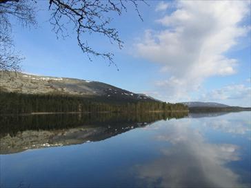 Lake Pallasjärvi.
Photo: Ahti Lepistö
General features
Pallasjärvi research area is located in the Pallas-Yllästunturi national park in North Finland. Lake Pallasjärvi (17.3 km2) is a northern boreal headwater lake with almost pristine catchment area (105.2 km2), being the largest of the Finnish sites belonging to the ICP IM Network. The Pallasjärvi research area is exposed to only minimal direct local pollution, and long-range transported air pollutants and climate change are the only external disturbances. The habitat types in the area range from boreal coniferous forests, open marshes and lakeside landscapes to treeless fells. The forest mainly consists of Norway spruce (Picea abies) with some scots pine (Pinus sylvestris) and deciduous trees (mainly Betula pubescens, some Populus tremula and Salix spp.).The catchment area has a great range of relief, from 267 m.a.s.l to 809 m.a.s.l.
Pallasjärvi research area was not originally established for Integrated Monitoring approach, but existing high-quality Arctic research infrastructure makes it suitable for monitoring of different ecosystem compartments simultaneously at the same location. The Pallasjärvi research infrastructure includes Pallas-Sodankylä observatory of the Finnish Meteorological Institute (FMI), the Pallasjärvi Research Forest of the Finnish Forest Research Institute (Metla), and Lake Pallasjärvi catchment research area of the Finnish Environment Institute (SYKE). The Pallasjärvi area is also part of FinLTSER network (Finnish Long-Term Socio-Ecological Research network). FMI has a high-tech unique infrastructure in the area including meteorology and climate change and air quality research/monitoring, such as eddy-covariance measurements on GHG fluxes, and activities of GAW (Global Atmospheric Watch research programme). Metla is also having a range of research projects ongoing, and an intensive forest monitoring site of ICP Forests level II is in the area. In Lake Pallasjärvi catchment research area (SYKE), the main monitoring activities are physical, chemical and biological monitoring of Lake Pallasjärvi with five stream/river stations (four main inlets and outlet with hydrological inflow and outflow measurements).
The monitoring of air quality and atmospheric deposition in the area started in 1991, and the intensive forest monitoring (ICP Forests, level II) started in 1995. Intensive hydrological and surface water chemistry monitoring of Lake Pallasjärvi catchment started in 2004.
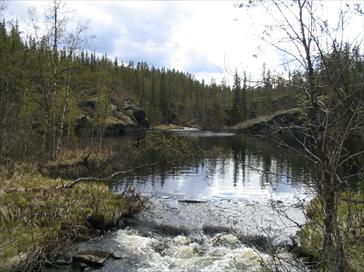 Pyhäjoki River, one of the sites for chemical and hydrological monitoring. Photo: Ahti Lepistö
| Country: |
Finland |
| Province/Municipality: |
Lapland/Kittilä |
| Area of site (hectares): |
105200 |
| Location (Lat/Long): |
68° 02’ N, 24° 11’ E |
| Elevation /above sea level): |
Min. 267 m, Max. 809 m |
| Annual mean precipitation: |
521 mm |
| Annual mean temperature: |
–1.0 C° |
| Dominant vegetation: |
Mesic heat forest (HMT),
Norway spruce (Picea abies) dominant tree |
| Dominant soil type: |
|
| Biotypes (hectares): |
|