ICP IM site FI03
|
|
|
|
|
|
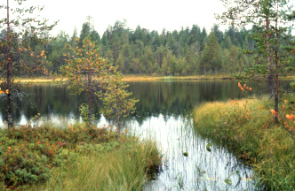
Lake Pieni Hietajärvi from the brook connecting the two lakes Pieni and Iso Hietajärvi, photo: Sakari Ruhkala.
|
General features
The Hietajärvi monitoring area is about 464 ha. It consists of two catchment areas with lakes. The forests are mainly mature or old, but the northern and eastern parts have young cultivated forest stands. Scots pine (Pinus sylvestris) is the dominant tree species. Norway spruce (Picea abies), birch (Betula spp.) and aspen (Populus tremula) occur among the pine. The last major forest fires occured about 140 years ago. Up until the beginning of the 20th century, small-scale slash-and-burn clearing and tar-burning was carried out by local peasants. The monitoring area is part of Patvinsuo National Park, which was established 1982.
The relief of the Hietajärvi area is rather low (49 m). Some parts of the northeastern catchment area have been difficult to define. Discharge is monitored at two wires, one measuring the inflow to Pieni Hietajärvi and the other the outflow from Iso Hietajärvi. A small brook connects the two lakes.
The first bulk precipitation and lake water chemistry samples were collected in 1987. Most of the other ICP IM subprogrammes started during the next two years. The groudwater tubes were installed in 1993, and intensive hydrobiological studies were conducted during 1990-1991.
|
Country:
|
Finland
|
|
Province/Municipality:
|
North Karelia/Lieksa
|
|
Area of site (hectares):
|
464
|
|
Location (Lat/Long):
|
63° 10' N, 30° 43' E
|
|
Elevation (above sea level):
|
Min: 165 m
Max: 214 m
|
|
Annual mean precipitation:
|
592 mm
|
|
Annual mean temperature:
|
2.0 °C
|
|
Dominant vegetation:
|
Submesic heath forests, Scots pine (Pinus sylvestris) dominant tree
|
|
Dominant soil type:
|
Over 1/3 of the area covered with fibric histosols, the remaining area divided between haplic and ferric podzols
|
|
Biotypes (hectares):
|
Upland forests 196, peatlands 156, lakes and ponds 106, other 6
|
Geology and soils
The bedrock in the Hietajärvi area is only rarely exposed. The bedrock information is based on outcrops that occur in the vicinity. The dominant rock types are granitoids. Porphyritic granodiorites appear to dominate large areas. The basement of the area is formed of 2500-million-year-old Archean acidic granitoids. Weathered bedrock (mostly porphyritic types) is observed in a few places.
The Hietajärvi area is supraaquatic. However, during the period when the ice was retreating, the meltwater washed the uppermost layers of loose till, removing the finer material. Some small eskers and esker-like remnants of glaciofluvial deposits occur in the eastern half of the catchment.
Over third of the the area is covered by fibric histosols, with the remaining area being mainly divided between haplic and ferric podzols. Gleyic properties, indicating a shallow fluctuating water table, are quite widespread and give rise to gleyic podzols and gleysols in a few places.
Vegetation
The Hietajärvi area lies in a transition belt between two vegetation zones. In terms of geobotanical zonation (Ahti et al. 1968) it lies in the boundary between the middle boreal and southern boreal zones.
The most common forest site types (Hämet-Ahti 1989, forest site types) are submesic heaths. Scots pine (Pinus sylvestris) is the dominant tree species. Norway spruce (Picea abies), birch (Betula spp.) and aspen (Populus tremula) occur among the pine. The peatlands are in a natural condition. The larger expances of mire display features of both main mire complex types, aapa mires and raised bogs. The central parts of the large mire areas are nearly ombrotrophic, but the typical physiognomy of raised bogs has not yet developed. This kind of mire vegetation is common in North karelia. Ombro-oligotrophic short sedge pine fens and pine fens with flarks, as well as treeless ombro-oligotrophic short sedge pine fens and flark fens are typical of large mire areas. Sphagnum fuscum bogs are also common.
Areas of mire types in Hietajärvi Integrated Monitoring area
|
Spruce mires
|
1 ha
|
|
Hummock level bogs/pine mires
|
86.8 ha
|
|
Poor pine fens
|
55.5 ha
|
|
Poor fens
|
12.7 ha
|
Maps
FI03 Basemap
FI03 Soilmaterial
FI03 Soiltype
References
Ahti, T. Hämet-Ahti, L. & Jalas, J. 1968: Vegetation zones and and their sections in northwestern Europe. - Ann. Bot. Fennici 5:169-211.
Bergström, I., K. Mäkelä and M. Starr (eds), 1995. Integrated Monitoring Programme in Finland: First National Report. Ministry of the Environment, Environment Policy Department, Helsinki. Rep. 1.
Hämet-Ahti, L. 1989: The main features of Finnish vegetation. In: Alalammi, P. (ed), Atlas of Finland. Folio 141-143, Vegetation and Flora:1-2. National Board of Survey, Geographical Society of Finland.
Tuominen, S. 2001. Hietajärven yhdennetyn seurannan alueen kasvillisuus. (Vegetation of the Hietajärvi Integrated monitoring area). Suomen ympräristö 456 (The Finnish Environment 456), Finnish Environment Institute. 59 s. (In Finnish). https://helda.helsinki.fi/handle/10138/40393